
Regensburg: remnants of Castra Regina on the Danube Limes
Above: former wall at the northeast corner of the Roman fort Castra Regina. Photo by Dr. Bernd Gross (image no. 7, Wiki CC3).
Regensburg is situated in central Bavaria, and is 1 and 1.5 hours from Nürnberg (Nuremberg) and München (Munich), respectively, with the train. While meandering through the Regensburg’s Old Town, it’s easy to forget most of this area was once occupied by a Roman fortress about 1800 years ago.
In 179 AD/CE, the Roman Empire established the fortress “Castra Regina”, or “fortress by the river Regen”, where the Regen enters the Danube river. The Danube became in effect a part of the Roman Empire’s northern frontier (“Danube Limes”). Emperor Marcus Aurelius recognized the need for extra security in the northern imperial province of Raetia where the Danube’s course reached its northernmost point. To ward off incursions by northern Germanic tribes, up to six thousand soldiers from the Third Italic Legion were stationed at the fortress.
At peak operation, the fortress encompassed an area 540 metres by 450 metres (24 hectares, or 60 acres) with a wall up to 10 metres (33 feet) high made of large sandstone blocks, 18 towers, 4 double-tower gates, and a wide trench. Within the grounds were barracks, headquarters building (principia), commanding officer’s own residence (praetorium), a military hospital (valetudinarium), granary (horrea), workshops, and stables. Civilians and support tradesmen built a settlement to the west of the fort. By the 5th-century, constant raids and migrations forced the Romans to abandon the area. A civilian settlement eventually grew over the fortress which is today’s Altstadt (Old Town)1.
The free-of-charge open-air museum includes restored remnants of the old Roman fortress complete with information displays in both English and German. The primary information location is at the parking garage at Dachauplatz (which is closed at night); the other three locations are accessible outdoors at any time.
The Porta Praetoria is one of multiple constituents in the tri-nation (AT DE SK) inscription for “Frontiers of the Roman Empire: Danube Limes” as UNESCO World Heritage Site (new, as of July 2021).
The map below shows the location of the Castra Regina encampment and locations of the “document Legionslagermauer” in the city’s Old Town. Click on the “arrow-window” icon at the upper-left corner of the map for additional details.
Porta Praetoria
The Porta Praetoria in Regensburg and the Porta Negra in Trier are said to be the only two remaining original Roman city gates in Germany. Regensburg’s Porta Praetoria (Praetorian Gate, Commander’s Gate) was built in 179 AD/CE.

Porta Praetoria, from the west (HL)
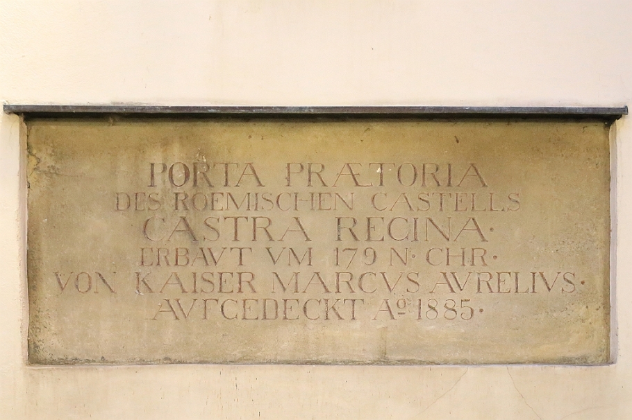
Plaque next to the gate: “Porta Praetoria des römischen Castells Castra Regina. Erbaut um 179 nach Christus von Kaiser Marcus Aurelius. Aufgedeckt anno 1885.” | Porta Praetoria of the Roman fort Castra Regina. Built in 179 AD/CE by Emperor Marcus Aurelius. Rediscovered in 1885. (HL)
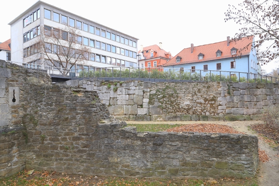
Hunnenplatz, “northeast corner”
Uncovered and freely accessible wall fragments from the Roman fortress along the east section, the northeast corner, and southeast corner make up what is now the “document Legionslagermauer”.
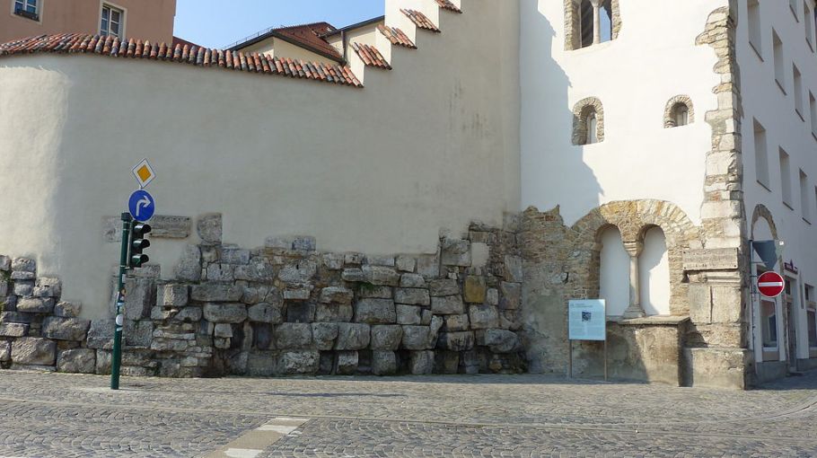
Photo by Dr. Bernd Gross (image no. 6, Wiki CC3).
Parkhaus Dachauplatz, “east wall”
The parking garage for Markthalle Regensburg at Dachauplatz was built to incorporate the longest remaining sections of the fortress’ stone wall. This location also houses primary information displays for “document Legionslagermauer.”
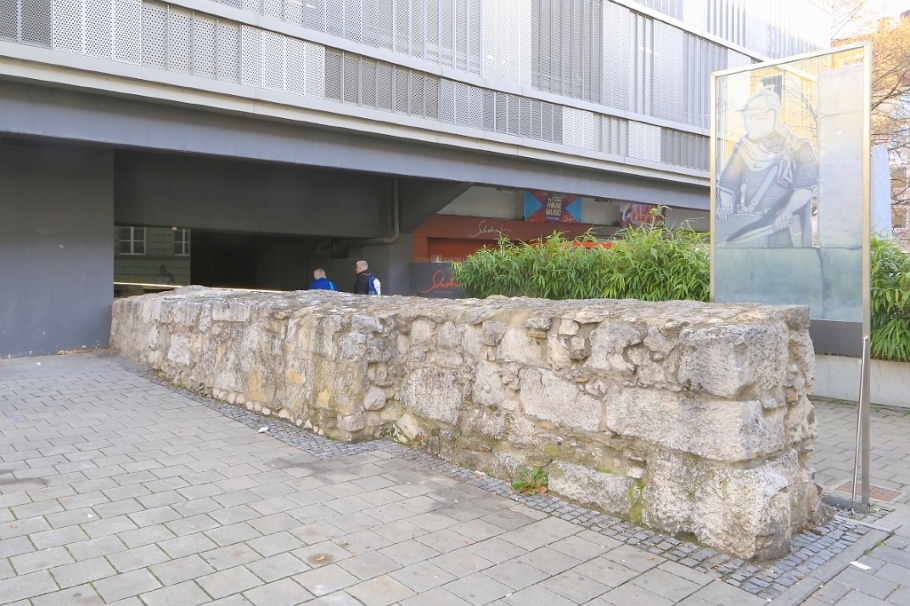
East wall incorporated into the carpark (HL)

At south entrance, facing north (HL)
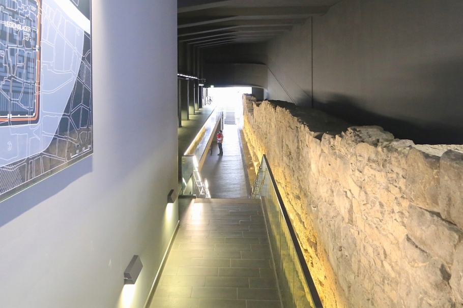
At north entrance, facing south (HL)
Ernst-Reuter-Platz, “southeast corner”
Uncovered and excavated in 1955 and 1961, walls at the fortress’ southeast corner were further renovated in 2013 to include new walkways and illumination. In places along this section there are medieval alterations to the original Roman construction.

Roman provinces, c. 150 AD/CE
Some thirty years before Castra Regina’s completion, the following map around 150 AD/CE shows the Roman Empire’s northern territory in what is now southeast France, southern Luxembourg, southern Germany, western Austria, Switzerland, Liechtenstein, and northern Italy. Civitas Remorum (Reims, France) is at the upper-left; Lugdunum (Lyon, France) is at the lower-left; and Patavium (Padua, Italy) is at the lower-right. At the upper-right is Castra Regina (Regensburg) at the Empire’s northern frontier in the Roman province of Raetia whose capital was Augusta Vindelicorum (present-day Augsburg).

Northern Roman provinces, c. 150 AD/CE. Map by Marco Zanoli (Wik CC3). Castra Regina is located at the upper right of the map. Provincial administrative capitals are underlined, and I’ve added some present-day city names in parentheses. North is at the top of the map.
More
1 Regensburg’s Old Town along with Stadtamhof on the north side of the Danube have been inscribed on the UNESCO World Heritage List since 2006.
• Document Legionslagermauer (English): Regensburg Tourism
• Document Legionslagermauer (German): Stadt Regensburg | Regensburg Tourismus
• Digital Atlas of the Roman Empire (English)
• UNESCO.de (German)
• World Heritage, City of Regensburg (English)
Thanks to Regensburg Tourism and Hotel Central Regensburg for their support and hospitality. I made the photos labeled “(HL)” with a Canon EOS6D mark1 on 13-15 Nov 2015. This post appears on Fotoeins Fotografie at fotoeins DOT com as http://wp.me/p1BIdT-808.

16 Responses to “Regensburg: remnants of Castra Regina on the Danube Limes”
You just gave some great information’s to a Bavarian, thank you for sharing. Wow Marc Aurelius went pretty far
LikeLiked by 1 person
Hi, Cornelia. It’s easy to forget how massive the Roman Empire was, and how the Romans managed to overcome the local populations as far as central England and present-day Palestine. What was interesting was (re-)learning the northern frontier of the Roman Empire against the “hordes” of the Germanic tribes, and that’s what made Castra Regina very interesting for me. Thanks for reading and for your comment!
LikeLiked by 1 person
Indeed. Living here in California, I sometimes forget from what a rich culture I came from.
LikeLiked by 1 person
Cornelia, living in North America it’s sometimes easy to forget that the rest of the world has a lot more recorded history. Difference also is that with First Nations/aboriginal peoples in North America the main facets of their histories are passed on as oral traditions.
LikeLike
Great post about my adopted German hometown!!
LikeLiked by 1 person
Hello, Lo. You already know you’re in a pretty nice town. Although I happened to visit while the Stone Bridge was under “wraps” and construction, I wanted more after my two days in town. Thanks for reading and for your comment!
LikeLike
I like reading about Roman history of places:)
LikeLiked by 1 person
Tanja, I enjoyed discovering, learning, and writing about the Roman history of the Castra Regina. 😊
LikeLiked by 2 people
cool!
LikeLiked by 1 person
Fascinating history. Remarkable conservation
Of truly world heritage monuments in Germany. Thank you For sharing.
LikeLiked by 1 person
Thank you for your comment and for stopping by. ¡Saludos desde Canadá!
LikeLiked by 1 person
Saludos! Ha!
LikeLiked by 1 person
[…] Southeast corner of the Castra Regina, at Ernst-Reuter-Platz – 15 Nov 2015 (HL, 6D1). […]
LikeLike
[…] The Raetian capital city had direct road connections to the frontier at the military encampment Castra Regina (Regensburg). The city’s location next to two rivers and its proximity to the Alps ensured […]
LikeLike
in 1971, my cousin took me to see the Roman walls and one of the gates. I remember it was quite a walk. My mother was from Straubing. I remember seeing a sign hanging outside a building where Napoleon stayed when he was in Regensburg. Americans have no idea of the history, they tear down and replace beautiful structures and build parking lots and modern monstrosities.
LikeLiked by 1 person
Debra, thanks for stopping by and for your comment!
LikeLike