Week 11 – no comment
To Styria and back to NRW.
World Heritage Sites designated and inscribed by UNESCO


Above/featured: Examples of the “Ringstraßenstil” historicism style at Maria Theresa Square, with Maria Theresa Monument at left and the Museum of Natural History at right. Photo, 15 May 2022 (X70).
• Can a street alone define its surrounding architecture?
• Do the buildings themselves establish the street’s visual impression?
• Is Vienna (un)fairly defined by the Ringstrasse and the inner city?
The answers, as always, are a little complicated.
Like many, I’m also fond of Vienna’s Ringstrasse (Ring Road), as a kind of “hello” and re-introduction to the city after my first visit in 2002. At 5 kilometres in length, the Ringstrasse is one of the longest streets in Europe, longer than the nearly 2-km Champs-Élysées in Paris and longer than the 4.5-km Nevsky Prospekt in St. Petersburg. The boulevard is surrounded by Prachtbauten (buildings of splendour), constructed in the architectural style of “historicism,” a big nod to classic “forms” reflecting structural “functions”. The late-19th century “Ringstrassenstil” (Ring Road architectural style) continued the practiced habit of choosing a historical style which best identified with the purpose of the building. For example, the Neo-Baroque architectural style is represented in the Civic Theater; the Neo-Classical style in the Parliament and New Palace; the Neo-Gothic style in City Hall and the Votive Church; and the Neo-Renaissance style in the museums, palatial mansions, Opera House, and the University.
On Christmas Day 1857, the Wiener Zeitung newspaper published an imperial decree written 5 days earlier (on 20 December) by Habsburg emperor Franz Joseph I. He ordered the demolition of the inner-city wall and the subsequent creation of a circular boulevard, bordered by grand buildings and filled with green spaces. The large outward extension of the inner city changed and influenced the urban development of Vienna, still seen to this very day.
It is my will that the extension of the inner city of Vienna should proceed as soon as possible, providing for appropriate connections between the city and the suburbs as well as the embellishment of my imperial residence and capital. To this end, I authorise the removal of the walls and fortifications of the inner city as well as the ditches around it …– Emperor Franz Joseph I: 20 Dec 1857, published 25 Dec 1857.
On 1 May 1865, Emperor Franz Josef unveiled the Ringstrasse in an official ceremony, even though large areas remained under construction. Ringstrasse structures included the religious and the secular, as well as the public and the private. The Ringstrasse symbolized the power of the imperial state, and the growth of a new arts and culture scene with the increasing popularity of coffee houses.
It’s also important to note the architectural impact made by the Jewish middle- and upper-class to integrate within the Habsburg empire. For example, the families Ephrussi, Epstein, and Todesco commissioned architect Theophil Hansen to construct palatial mansions as visible manifestations and partial realization of the dream of many Viennese Jews: assimilation into and emancipation within Viennese society. (Viennese journalist and political activist Theodor Herzl might have had a different opinion about that.)
For residents and long-term visitors today, it’s entirely possible to fit into the unintended shape and mentality of the “modern” city: that the inner-city wall was simply replaced by a different wall of “economic class”, that the architectural callback to historicism “freezes” the inner-city in time, and that like many, I can live, traverse, and work in the outer districts and avoid entering the inner city.
For short-term visitors today, the Ringstrasse buildings form a golden shiny “ring” around the “fingers” of the U1 and U3 metro lines traversing through the UNESCO World Heritage inscribed inner-city. For these visitors, all that’s needed for their limited time in Vienna is the inner city.
Above/featured: Judenplatz at night. The Holocaust memorial is in the foreground at centre. In the background are “To the little trinity” at centre and Misrachi House (Museum Judenplatz) at right. Photo, 10 Jun 2022.
At Judenplatz are clear visual reminders of the city’s first Jewish community in medieval times.
The first Jewish community in Vienna settled around present-day Judenplatz in the Middle Ages with mention in written documents dated mid- to late-13th century AD/CE. Daily Jewish life thrived around the Or-Sarua Synagogue, the Jewish School, and the Mikveh ritual bath. The community along with the surrounding Jewish neighbourhood came to an end with the Pogrom of 1421. Catholic Habsburg Duke Albrecht II rolled out a decree (Wiener Geserah, Vienna Gesera) which legitimatized the expulsion, incarceration, torture, and murder of some 800 Jewish residents; accompanied by destruction and forced takeover of buildings and property.
Below I highlight remnants and traces to the medieval Jewish community at this square in central Vienna.
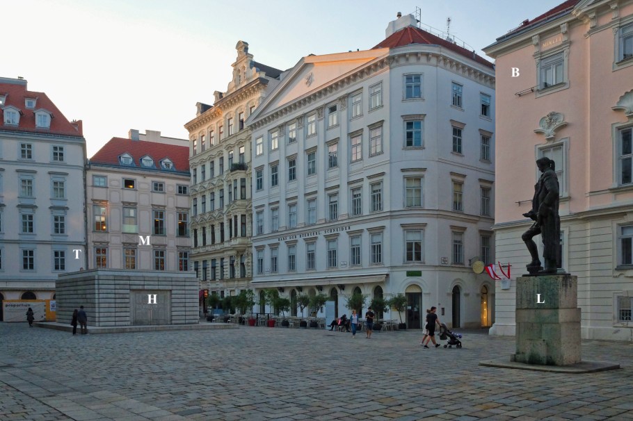
Facing northwest: B, Bohemian Chancellery; H, Holocaust Memorial; L, Lessing monument; M, Misrachi House; T, To the little Trinity. Photo, 20 May 2018.
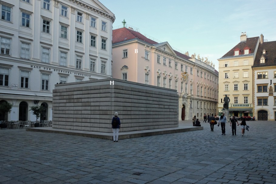
Facing southeast: B, Bohemian Chancellery; J, Jordan House; H, Holocaust memorial; L, Lessing monument. Photo, 20 May 2018.
Above/featured: Aspern lake at the Aspern Seestadt housing development in the 22nd district. At right in the background to the north are the Danube Tower and northern hills. Photo, 7 Jun 2022.
From early-2002 to mid-2003, I lived and worked in Heidelberg, and I travelled to Vienna at least six times across all seasons for collaboration work between MPIA and the University of Vienna. Unfortunately, I didn’t own a camera, and I have zero images from that time. “Oiiida.”
After a 15-year pause, I returned to Vienna for one week in May 2018 for the 100-year anniversary of Vienna Modernism. I brought 2 cameras, and I made a few photographs here and there. I’ve always needed more, and four years later in May 2022, I stayed in Vienna for four weeks.
The historic bread- and pastry-making company, Anker, once had a motto known among the Viennese:
Worauf freut sich der Wiener, wenn er vom Urlaub kommt? Auf Hochquellwasser und Ankerbrot.
To what do the Viennese look forward after returning from vacation? Spring water and Ankerbrot.
For all of us who’re visitors to Vienna, I put forward the modified question:
Worauf freut sich ein(e) Besucher(in), wenn man nach Wien kommt?
To what does a visitor look forward in Vienna?
There are many answers for many people. There’s art, coffee, Jugendstil, music, wine; these are only five in a lengthy list. Vienna is more than a desirable visitor location; the city reclaimed the top spot in the The Economist’s EIU Global Liveability Index for 2022.
I got to explore at least one point of interest in each of the city’s 23 Bezirke or districts. Not only did I spend a lot of time in the inner city or 1st district, but I also made my fair share in the 6th, 9th, 18th, and 19th districts. Below I provide from each of the city’s 23 districts a couple of personal highlights which may be of interest to both resident and visitor. There are more interesting locations, about which I’ll describe separately.
