4 Dec 2017 0001 GMT+0000
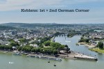
Above: West view to Deutsches Eck from Ehrenbreitstein. 2015 photo by Taxiarchos228 (Wladyslaw Sojka). I’ve added the following labels: (1) Seilbahn/Gondola, (2) St. Kastor Basilica, (3) Deutschherrenhaus, (4) first Deutsches Eck, (5) Memorial to German Unity (Kaiser Wilhelm Memorial), (6) reclamation in the late 19th-century, (7) second Deutsches Eck.
Many will know, have seen, or have read about the Deutsches Eck (German Corner) in the German city of Koblenz. The river city has plenty to provide: visitors wander into the vineyards to sip on crisp white wine from local grapes, vacation on long cabin-boats to enjoy the river scenery, or explore the surrounding Upper Rhine River Valley.
But Koblenz is also well known by virtue of its name after the junction where the rivers Moselle and Rhine meet. By the first-century AD/CE, the Romans had built for strategic protection a fort1 called “Castellum apud Confluentes“, Latin for “the castle at the confluence”. What most commonly acknowledge as the Deutsches Eck (German corner) is not the original location. Half concealed among the trees some 200 metres back near the Deutschherrenhaus is the first location of the Deutsches Eck.
What follows:
The locations of the first and second Deutsches Eck are indicated by red cross and orange flag, respectively, in the map below. The approximate shoreline before 1850 is shown as a thick blue line. Click on the “arrow-window” icon at the upper-left corner for the legend.

(A) First Deutsches Eck, with the Cross of the German (Teutonic) Order at the base of the former corner tower. At centre-right is the Gate of the Knights of the German Order, leading into the inner courtyard of the Deutschherrenhaus with its own cross near the rooftop.

(B) Left-centre: cross of the German (Teutonic) Order at the 1st Deutsches Eck. At the location where I made this photo, I would’ve been treading water in the Moselle river before 1850; see the archival images (G) and (H) below.

(C) Kaiser Wilhelm equestrian statue and Memorial, inaugurated in 1897.
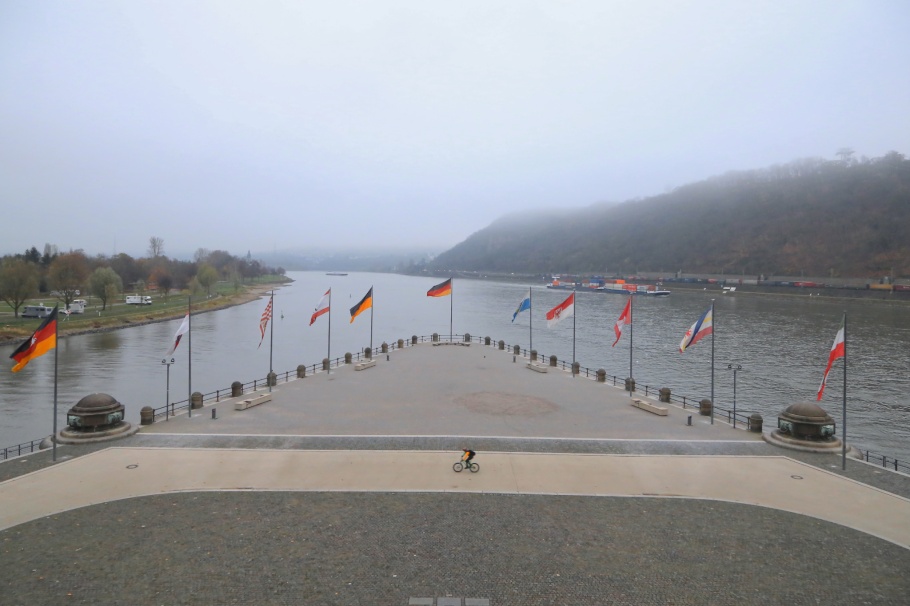
(D) From the Kaiser Wilhelm equestrian statue, north to the 2nd Deutsches Eck and confluence (junction) of the Moselle and Rhine rivers.

(E) Facing south from 2nd Deutsches Eck: Memorial to German Unity, and flags for 16 German federal states, Germany, the European Union, and the U.S.; Kaiser Wilhelm Memorial.

(F) Facing north at the 2nd Deutsches Eck, to the German flag and the confluence of the Moselle river (left) with the Rhine.
Near the junction where the Moselle river joins the Rhine, St. Kastor Church2 had long been present since its establishment in the 9th-century AD/CE. In 1216, the Deutscher Orden (Teutonic or German Order3) founded at the river junction the Deutschherrenhaus or the Deutschordenhaus (House of the Knights of the German Order) including a hospital, all next to St. Kastor Church. The favourable location would soon be called the “Deutscher Ordt” (Place/Ort of the German Order/Orden) and later the “Deutsches Eck” (German Corner).
The Cross of the Teutonic Order (Crux Ordis Teutonicorum) appears at the base of the corner tower as part of the wall surrounding the Deutschherrenhaus. The cross would have been visible to anyone sailing the waters of the two rivers. With the symbol originating from the 13th-century as a black-and-white cross pattée, the emblem formed the basis for the development of the Iron Cross (Eisernes Kreuz) in the early 19th-century4.
Land reclamation north of the Deutschherrenhaus moved the location of the Deutsches Eck to the northeast by about 200 metres by the mid- to late-19th century. Standing prominently at the “new” Deutsches Eck, the Kaiser Wilhelm memorial with an equestrian statue standing 14 metres (46 feet) tall was inaugurated in 1897, built in acknowledgement of the 1871 unification of German lands into a greater German Empire. After destruction in the Second World War, the remnants would be reconstructed and incorporated into a larger Memorial to German Unity in 1953. Plaques embedded into the cobblestone provide descriptions in German, English, and French about the context of the memorial in relation to modern Germany.
The second world war and subsequent years took their toll on the Deutschherrenhaus; complete reconstruction of the building began in 1989. By 1992 the site became home to the Ludwig Museum to house the city’s collection of modern and contemporary art. The Museum celebrated in 2016 the 800th anniversary of the Deutschherrenhaus and presence of the Deutscher Orden in Koblenz.
The Deutsches Eck and the city of Koblenz are included within the inscription area for the Upper Middle Rhine Valley UNESCO World Heritage Site (2002).

(G) Mid-17th century Koblenz, facing east to the Ehrenbreistein-Philippsburg complex. At right is the Deutschordenhaus (Deutschherrenhaus) with the corner tower and gate indicated; compare this image with images (A) and (B) above. Copper engraving from the 1646 volume “Topographia Archiepiscopatuum Moguntinensis, Treuirensis et Coloniensis” by Matthäus Merian. Sources: Digitale Texte Universität Köln and Münchener DigitalisierungsZentrum.

(H) 1847 map with north up: where the Moselle (Mosel-Fluß) meets the Rhine, with the Deutschherrenhaus at the corner and junction. From “Coblenz und Umgebung in der Brusttasche” (1847); sources: Stadarchiv Koblenz and dilibri Rheinland-Pfalz.

(I) About 1875, west view of Koblenz and the Deutsches Eck. I’ve added the white dashed line to outline the construction that would take place over the next two decades until the Kaiser-Wilhelm Memorial was inaugurated in 1897; compare this 1875 view with the modern-day view at the very top of this post. Source: Stadtarchiv Koblenz (unknown photographer).

(J) 1888 map with north up. Continuing land reclamation has produced the “Mosel-Werft-Bassin”, extending north from the “old” Deutsches Eck and Deutschherrenhaus. Source: Stadtarchiv Koblenz.

(K) 1905 map with north up. The location of the “new” and 2nd Deutsches Eck is clearly labelled upon completion of land reclamation and inauguration of the Kaiser Wilhelm monument. Sources: “Meyers Grosses Konversations-Lexikon” (1905) and Wikimedia Commons.
1 After over a century of searching throughout Koblenz’s Old Town for existence of the original Roman settlement, construction in 2008 near St. Kastor church revealed the existence of a moat or trench (8-meters long, 4-meters wide, and 2.5-metres deep) for a castle dating back to the Roman Empire.
2 St. Kastor Church was rebuilt in the 11th to 12th-century, destroyed in the Second World War, and subsequently rebuilt in the mid-1950s.
3 During the medieval Crusades, the Deutscher Orden was founded about 1190 AD/CE in the Mediterranean port city of Acre (Akko/Akka) in present-day northern Israel. The order’s present-day headquarters and central archives are in Vienna, Austria with satellites throughout Europe including Germany.
4 The Iron Cross is prominent and central at the 1821 Prussian National Monument on the top of a hill in Berlin’s Viktoriepark (Victoria Park). For the cross and hill, the surrounding area and neighbourhood are commonly known as Kreuzberg (“cross mountain”).
• Regional Geschichten
• Schängel Geschichten
• KuLaDig: Kultur.Landschaft.Digital (“Frührömisches Kastell Koblenz”)
• Arenberg
Thanks to Koblenz Touristik and Romantic Germany for advice and support. Koblenz is a featured city in the Historic Highlights of Germany. The featured photo at top is by Wladyslaw Sojka (via Wikipedia). I made photos labelled (A) to (F) on 26 and 27 November 2015. This post appears on Fotoeins Fotografie at fotoeins.com as http://wp.me/p1BIdT-7IN.

Posted by HL fotoeins
Categories: Architecture, Culture, Europe, Germany, Photography, Travel, UNESCO World Heritage
Tags: Basilika St. Kastor, Deutscher Orden, Deutsches Eck, Deutschherrenhaus, Deutschherrenorden, Deutschland, Deutschordenshaus, fotoeins, German Corner, Historic Highlights of Germany, Kastorkirche, Koblenz, Ludwig Museum, Middle Rhine, Mittelrhein, Mosel, Moselle, Moselle river, Oberes Mittelrheintal, Orden der Brueder vom Deutschen Haus der Heiligen Maria in Jerusalem, Order of Brothers of the German House of Saint Mary in Jerusalem, Ordo domus Sanctae Mariae Theutonicorum Hierosolymitanorum, Rhein, Rheinland-Pfalz, Rhine, Rhine river, river, Romantic Germany, Teutonic Order, UNESCO, Upper Middle Rhine Valley, Welterbe, Weltnaturerbe, World Heritage
Mobile Site | Full Site
Get a free blog at WordPress.com Theme: WordPress Mobile Edition by Alex King.
As always I love your posts from Germany, it teaches me a lot about my home country.
LikeLiked by 1 person
By corneliaweberphotography on 4 Dec 2017 at 0448 GMT+0000
Thanks, Cornelia, and you’re welcome! I approached writing this from questions some might ask: “What do you mean this isn’t the original Deutsches Eck? Where is the first Eck? How did this happen?” 😉
LikeLiked by 1 person
By fotoeins on 4 Dec 2017 at 1956 GMT+0000
Where does the gondola go?
LikeLiked by 1 person
By Bespoke Traveler on 4 Dec 2017 at 2021 GMT+0000
Excellent question: in summer season, the cable car is a speedy way to go over the Rhine river between the city’s Altstadt on the west bank and Ehrenbreitstein Fortress on the east bank. Thanks for reading!
LikeLiked by 1 person
By fotoeins on 4 Dec 2017 at 2028 GMT+0000
[…] (left) flows into the Rhein at the 2nd Deutsches Eck – 27 Nov 2015 […]
LikeLike
By World Rivers Day: an RTW selection | Fotoeins Fotografie on 10 Mar 2018 at 0105 GMT+0000
[…] In central Vienna, the Deutschordenshaus building is the world headquarters for the Order of the Teutonic Knights of St. Mary’s hospital in Jerusalem, also known as the Teutonic Order. The group has roots in the Third Crusade, established as a military hospital near the Mediterranean port city of Acre (Akko/Akka) around 1190 AD/CE. The Order established satellites all over Europe, including Vienna whose presence here was established in the early 13th-century. In 1809, the Order moved its headquarters to Vienna. Graced with 17th- and 18th-century design, the building today houses not only offices, but also its central archives and Treasury (Schatzkammer). As seen on the door in the image above, the Order’s symbol is the Cross of the Teutonic Order (Crux Ordis Teutonicorum), very much like the one visible at the 1st “Deutsches Eck” (German Corner) in Koblenz. […]
LikeLike
By Fotoeins Friday in Vienna Old Town: Teutonic Order | Fotoeins Fotografie on 28 Aug 2020 at 0002 GMT+0000
[…] Separate full post: 1st & 2nd Deutsches Eck. […]
LikeLike
By My Germany: 32 (of 51) UNESCO WH Sites | Fotoeins Fotografie on 17 Aug 2021 at 0127 GMT+0000