Fotoeins Fotografie

location bifurcation, place & home

Posts tagged ‘river’

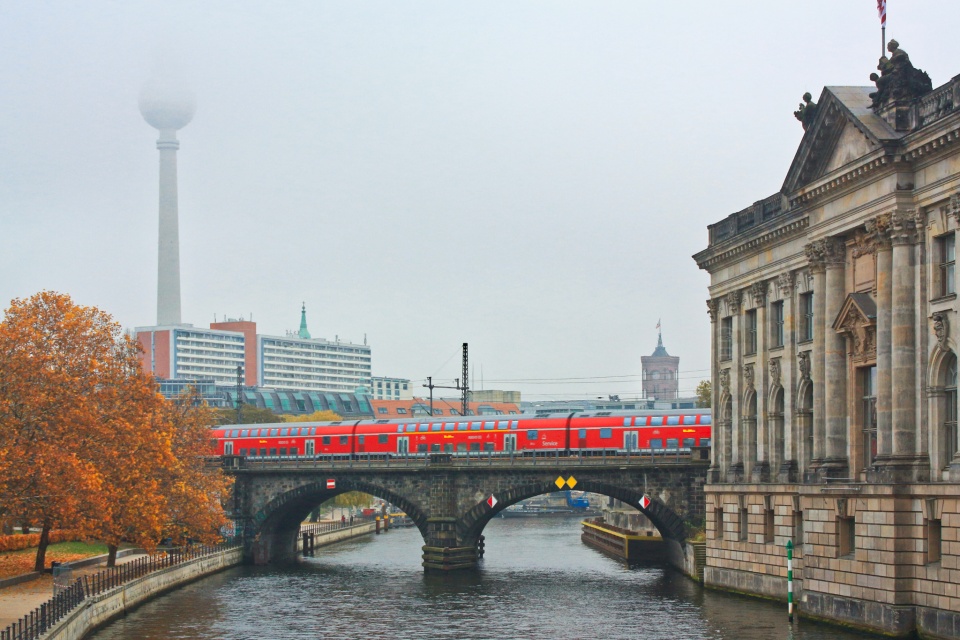
Monbijoubrücke, Museumsinsel, Fernsehturm, ThatTowerAgain, Berlin, Germany, fotoeins.com

Fotoeins Friday: RTW10, forty-seven

10 years ago, I began an around-the-world (RTW) journey lasting 389 consecutive days, from 24 December 2011 to 15 January 2013 inclusive.

16 November 2012.

For me, this familiar scene says a lot of “home”.

In this southeast view from Berlin’s Monbijou Bridge, lingering autumn fog and mist partly obscures city landmark Fernsehturm (Television Tower) in the background at left. Also visible are the Rotes Rathaus at centre-right and the imposing structure housing the Bode Museum on the Museum Island at right. Railway tracks cross the island, “squeezed” between the Bode Museum and the Pergamon Museum. A bright-red Deutsche Bahn regional train crosses over the Spree river from left to right (east to west) on its way to Friedrichstrasse station and beyond to Central Station.

I made the image on 16 Nov 2012 with a Canon EOS450D (Rebel XSi) and these settings: 1/125-sec, f/8, ISO800, and 42mm focal length (67mm full-frame equivalent). This post appears on Fotoeins Fotografie at fotoeins DOT com as https://wp.me/p1BIdT-mIi.

Leopoldsberg, 19. Bezirk, Döbling, Wien, Vienna, Austria, Österreich, fotoeins.com

My Vienna: 1 capital city, 4 Danubes

Above/featured: Southeast view from Leopoldsberg in the city’s 19th district. Visible are the waters of the Old Danube, New Danube, Danube, and the Danube Canal. Photo, 1 Jun 2022.

Vienna loves the Danube so much that the city now has four water features with the label “Donau”.

  • Alte Donau (Old Danube)
  • Donau (Danube)
  • Donaukanal (Danube Canal)
  • Neue Donau (New Danube)

All of it is thanks to the regulation of the Danube river after the city of Vienna and the surrounding region had to put up with frequent flooding. Vienna embarked on works of flood-control engineering in two major periods of construction: 1870 to 1875, and 1972 to 1988.

Once a former arm of the river, the Old Danube is now a closed body of water, a crescent-shaped lake that’s been cutoff by the “linearization” of the Danube. A former natural arm of the river, the Danube Canal was regulated for the first time around 1600. Most visitors will encounter the Danube Canal which is best integrated with the city with the appearance of multiple road and rail crossings and the canal’s reach with 7 of the 23 city’s districts. The Danube river proper was completely regulated and straightened during the second engineering period, which also saw construction of the New Danube as a secondary flood channel in parallel with the primary river.


( Click here for images and more )

Schleusenbrücke Wehr 1, Neue Donau, 22. Bezirk, Donaustadt, Wien, Vienna, Austria, Österreich, fotoeins.com

My Vienna: 7 city views for free from modest heights

At the eastern limit of the Alps, the city of Vienna is built at the “low end” where the hills meet the Danube river, at a minimum altitude of about 150 metres (500 feet) above sea-level. Visitors to the Austrian capital city who don’t have much time but want a broad overview of the city will make their way to one or all of the Donauturm (Danube Tower), Riesenrad (Ferris Wheel), and Stephansdom (St. Stephen’s Cathedral). Each of these landmarks requires the price of admission to get up high in the sky.

For other views at more modest heights, you’ll see there are options, especially because I’ve set foot in all 23 of the city’s districts. Below I highlight seven locations; all are free (zero charge) to access. All but one are well outside the inner city for the opportunity to explore other city districts and to gain a better sense of the physical size of the city.


( Click here for more )

Mekong River, Mekong delta, Mekong River Delta, song Tien, Tien Giang, river delta, My Tho, Vietnam, fotoeins.com

Fotoeins Friday: RTW10, twenty-six

10 years ago, I began an around-the-world (RTW) journey lasting 389 consecutive days, from 24 December 2011 to 15 January 2013 inclusive.

26 June 2012.

I’m spending a few days in southern Vietnam with a base out of Ho Chi Minh City (HCMC). On a day trip from HCMC to the area around Mỹ Tho, I’m on one of the islands in the Mekong river delta. I’m on a horse-drawn cart where a boat on the other side of the island will take me to the next destination in the delta. Unfortunately, I don’t speak any Vietnamese: I simply shrug, I nod and smile, and I follow. But one thing is clear: there’s a perfect alliance of measured movement among human, horse, bicycle, and motorcycle on this narrow paved road.

I made the image on 26 Jun 2012 with a Canon EOS450D (Rebel XSi) and these settings: 1/250-sec, f/8, ISO100, and 18mm focal length (29mm full-frame equivalent). This post appears on Fotoeins Fotografie at fotoeins DOT com as https://wp.me/p1BIdT-m8r.

Pier 5, Patapsco River, Domino Sugars, Baltimore, MD, USA, fotoeins.com

Fotoeins Friday: RTW10, eighteen

10 years ago, I began an around-the-world (RTW) journey lasting 389 consecutive days, from 24 December 2011 to 15 January 2013 inclusive.

27 April 2012.

It’s a beautiful warm sunny spring day in Baltimore, Maryland, and I’m on a stroll around the city’s waterfront. Near the Seven Foot Knoll Lighthouse at Pier 5, this view southeast reaches across the Patapsco River to the big 1951 neon sign for the Domino Sugar company; the factory building is an active refinery facility continuing to produce sugar.

In 2021, the company replaced the deteriorating neon sign with an LED-sign which was relit for the July national holiday.

I made the image above on 27 Apr 2012 with a Canon EOS450D (Rebel XSi) and these settings: 1/250-sec, f/8, ISO100, and 55mm focal length (88mm full-frame equivalent). My thanks to MB and MK for making my visit to Baltimore possible. This post appears on Fotoeins Fotografie at fotoeins DOT com as https://wp.me/p1BIdT-lW6.

My Salzburg: city views from above on Mönchsberg

In Salzburg, I’m motivated by a search for Mozart and for signs of modernity. I’ve already examined part of the city through its art: what more can Salzburg offer?

Excellent views of the city and surroundings.

The Mönchberg hill on which the Hohensalzburg fortress sits provides many viewpoints over the city. You can walk along the entire length of Mönchberg for varying perspectives, or you can approach a number of the viewpoints separately.

I ascended and traversed the hill on foot from southeast to northeast, beginning from Kapitelplatz to the viewpoints just north of the Museum der Moderne. I returned to the Old Town below with the MönchsbergAufzug elevator which is a part of Salzburg’s public transport.


( Click here for images and more )

Embalse Puclaro, Puclaro, Rio Elqui, Elqui river, Region de Coquimbo, La Serena, Chile, fotoeins.com

Fotoeins Friday in La Serena: Puclaro dam & reservoir

I’m highlighting the La Serena-Coquimbo area in north-central Chile, where I lived from 2006 to 2011 after many visits to the area between mid-1990s and the early aughts.

In 1999, the Elqui river was dammed to control water flow into agricultural lands downstream and beyond to the twin cities of La Serena and Coquimbo. The reservoir behind the dam drowned a number of villages. The view above from the dam faces east to the Andes, the continent’s raised mountain spine.

I made the photo above on 13 Sep 2009 with a Canon EOS450D/Rebel XSi and the following settings: 1/80-sec, f/13, ISO200, and 18mm focal length (29mm full-frame equivalent). This post appears on Fotoeins Fotografie at fotoeins DOT com as https://wp.me/p1BIdT-jLl.

Osterspai, Rhein, Rhine, Oberes Mittelrheintal, Upper Middle Rhine Valley, Germany, Deutschland, fotoeins.com

Fotoeins Friday on the Middle Rhine: Osterspai

24 May 2016.

This image is of the town of Osterspai, near “kilometre 575” (distance north of the Rhine Falls in Switzerland). In town at left-centre is the Catholic St. Martin’s church, first established in town in 1076 AD/CE. Accompanying the scene are two river boats and two bicyclists in the foreground.

I’m on board a Deutsche Bahn IC (InterCity) train from Heidelberg north to Cologne, along the left (west) bank of the Rhine river. The slower train along the river bank and more scheduled stops allows further opportunities to photograph the right (east) bank of the Rhine. Although overcast, the mid-morning early-afternoon train means any diffuse light will originate “behind” me from the south, and the landscapes will either be front- or side-lit.

In this series, I show images of the Rhine between Mainz and Koblenz which is the area included within the Oberes Mittelrheintal (Upper Middle Rhine Valley) inscribed in 2002 as UNESCO World Heritage Site.

I made the image above on 24 May 2016 with a Canon EOS6D mark1, 24-105L glass, and the following settings: 1/160-sec, f/9, ISO1000, and 70mm focal length. This post appears on Fotoeins Fotografie at fotoeins DOT com as https://wp.me/p1BIdT-hMk.

St. Goarshausen, Burg Katz, Rhein, Rhine, Oberes Mittelrheintal, Upper Middle Rhine Valley, Germany, Deutschland, fotoeins.com

Fotoeins Friday on the Middle Rhine: Sankt Goarshausen

24 May 2016.

This image is of the town of Sankt Goarshausen, near “kilometre 556” (distance north of the Rhine Falls in Switzerland). Above town (at upper right) is historical landmark Burg Katz, a reconstruction of a medieval castle and is under private ownership.

I’m on board a Deutsche Bahn IC (InterCity) train from Heidelberg north to Cologne, along the left (west) bank of the Rhine river. The slower train along the river bank and more scheduled stops allows further opportunities to photograph the right (east) bank of the Rhine. Although overcast, the mid-morning early-afternoon train means any diffuse light will originate “behind” me from the south, and the landscapes will either be front- or side-lit.

In this series, I portray images of the Rhine between Mainz and Koblenz which is the area included within the Oberes Mittelrheintal (Upper Middle Rhine Valley) inscribed in 2002 as UNESCO World Heritage Site.

I made the image above on 24 May 2016 with a Canon EOS6D mark1, 24-105L glass, and the following settings: 1/250-sec, f/10, ISO1000, and 75mm focal length. This post appears on Fotoeins Fotografie at fotoeins DOT com as https://wp.me/p1BIdT-hMa.

Kaub, Burg Gutenfels, Rhein, Rhine, Oberes Mittelrheintal, Upper Middle Rhine Valley, Germany, Deutschland, fotoeins.com

Fotoeins Friday on the Middle Rhine: Kaub, Gutenfels

24 May 2016.

I’m on board a Deutsche Bahn IC (InterCity) train from Heidelberg north to Cologne, along the left (west) bank of the Rhine river. The slower train along the river bank and more scheduled stops allows further opportunities to photograph the right (east) bank of the Rhine. Although overcast, the mid-morning early-afternoon train means any diffuse light will originate “behind” me from the south, and the landscapes will either be front- or side-lit.

In this series, I portray images of the Rhine between Mainz and Koblenz which is the area included within the Oberes Mittelrheintal (Upper Middle Rhine Valley) inscribed in 2002 as UNESCO World Heritage Site.

This image is of the town of Kaub, near “kilometre 546” (distance north of the Rhine Falls in Switzerland). Above town sits historical landmark Burg Gutenfels on the slope accompanied by vineyards.

I made the image above on 24 May 2016 with a Canon EOS6D mark1, 24-105L glass, and the following settings: 1/200-sec, f/9, ISO1000, and 50mm focal length. This post appears on Fotoeins Fotografie at fotoeins DOT com as https://wp.me/p1BIdT-hLW.

%d bloggers like this: