1-day drive, US: Santa Fe to Flagstaff
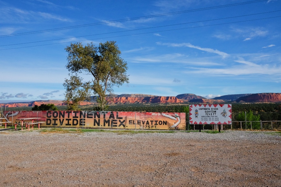
Above/featured: Continental Divide. Rising to the north are red Entrada sandstone cliffs (Iyanbito member) from the middle Jurassic period about 170 million years ago. The cliffs are part of a geologic formation extending from northwest New Mexico into northeast Arizona, southeast Utah, and west-central Colorado.
The following takes place entirely on travel day 9 (12 Oct 2018) in the American Southwest. From Santa Fe, New Mexico to our destination Flagstaff, Arizona, the day-long drive began on the short leg I-25 south to Albuquerque. This stretch of I-25 is along a part of the colonial road El Camino Real and parallel to the pre-1937 alignment of the now-famous highway US route 66 (US-66). In Albuquerque, we turned right onto I-40, heading westbound for the New Mexico-Arizona state border and beyond. The total distance was a little over 650 kilometres (400+ miles).
• Historic Route 66 (US DoT Federal Highway Administration)
• New Mexico US-66 Association
• Historic Route 66 Association of Arizona
• Why Route 66 became America’s most famous road, Vox on YouTube, 16 Aug 2019.
I-40 west from NM to AZ
- Albuquerque, NM
- Continental Divide, NM
- Gallup, NM
- Petrified Forest National Park, AZ
- Holbrook, AZ
- Winslow, AZ
- Flagstaff, AZ
Albuquerque, NM
We’d already spent a couple of days in Albuquerque for the annual hot-air balloon festival, and we saw where US-66 had intersected itself in the city centre. In its initial alignment, US-66 from Santa Fe passed through Albuquerque north to south as 4th Street. After the highway’s realignment in 1937, US-66 skipped Santa Fe and passed east to west as Central Avenue through Albuquerque’s downtown and historic Old Town. These two alignments intersect at Central and 4th. Nearby is the historical landmark KiMo Theatre on Central Avenue, one of many city highlights I described here.
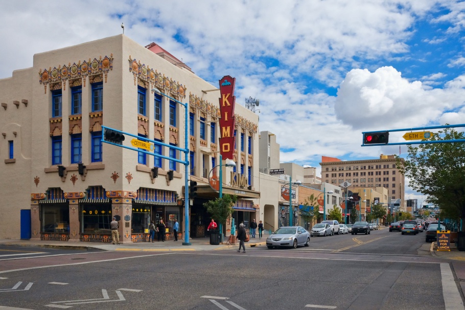
KiMo Theatre, Central Avenue & 5th Street NW (9 Oct 2018).
Continental Divide, NM
The road segment of US-66 labelled state road NM-122 serves as frontage road next to I-40 between Milan and the unincorporated community of Continental Divide. West from Milan, a 9-mile stretch is a four-lane road completed in 1951 when several sections of US-66 were widened. The remaining 23 miles narrows into a two-lane road which runs parallel to I-40 and above the tracks of the former Atchison, Topeka and Santa Fe Railway (ATSF Railway). The road ascends towards Continental Divide, where US-66 reaches its highest elevation of 2214 metres (7263 feet) at Campbell Pass. The frontage road becomes a closed cul-de-sac just west of Continental Divide (NPS). The North American continental divide is a geographical ridge forming a watershed which separates rivers flowing west into the Pacific Ocean from rivers flowing east into the Gulf of Mexico and the Atlantic Ocean.
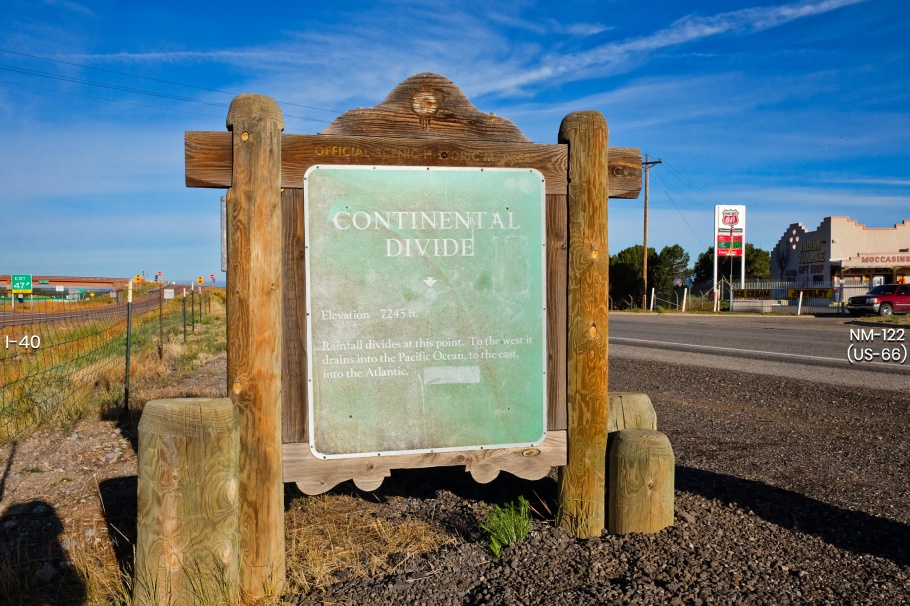
Facing west, with I-40 at left and NM-122 at right. The sign reads: “Continental Divide: elevation 7245 feet. Rainfall divides at this point (on the ground). To the west rivers drain into the Pacific; to the east rivers drain into the Atlantic.”
On the Pacific side of the divide.
Gallup, NM
Only 35 kilometres (22 miles) from the New Mexico-Arizona border, we stop at Gallup, a railway depot town and a stop for weary drivers on the highway. We’re in town to see a mural dedicated to the Navajo Code Talkers who served as part of U.S. forces in the Pacific theatre of World War 2. Gallup is considered an unofficial capital of and gateway into Indian country and the Navajo Nation in New Mexico. There’s always surprises and we found our bonuses with a Lloyd Moylan 1940 “History of the Gallup Region” mural inside the McKinley County Courthouse and at the old-school charming nostalgia of driving culture inside the Hotel El Rancho.
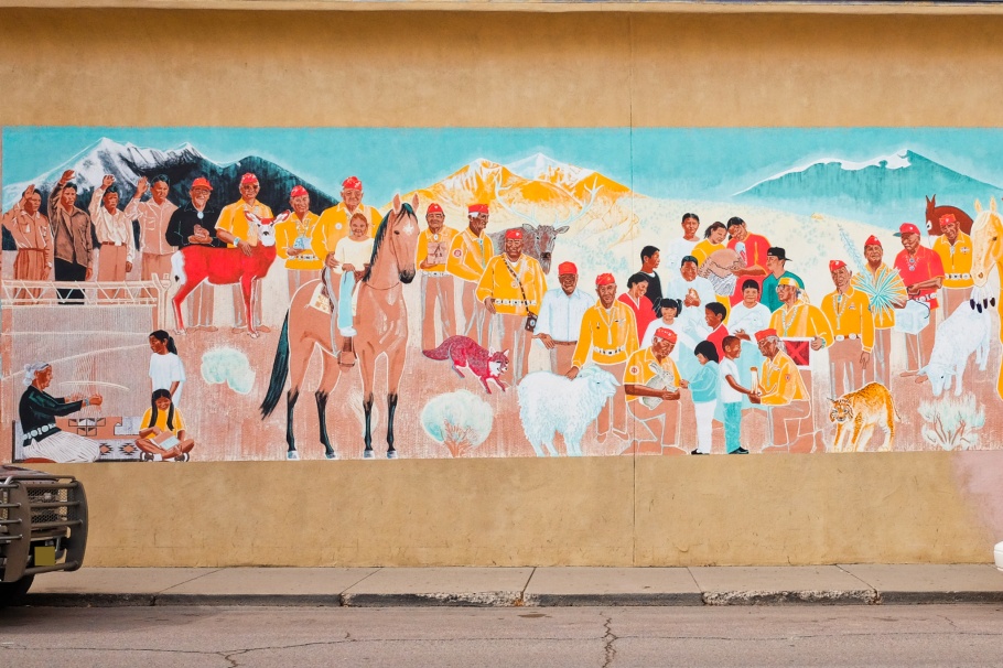
A part of the Navajo Code Talkers mural by New Mexico artist Be Sargent.
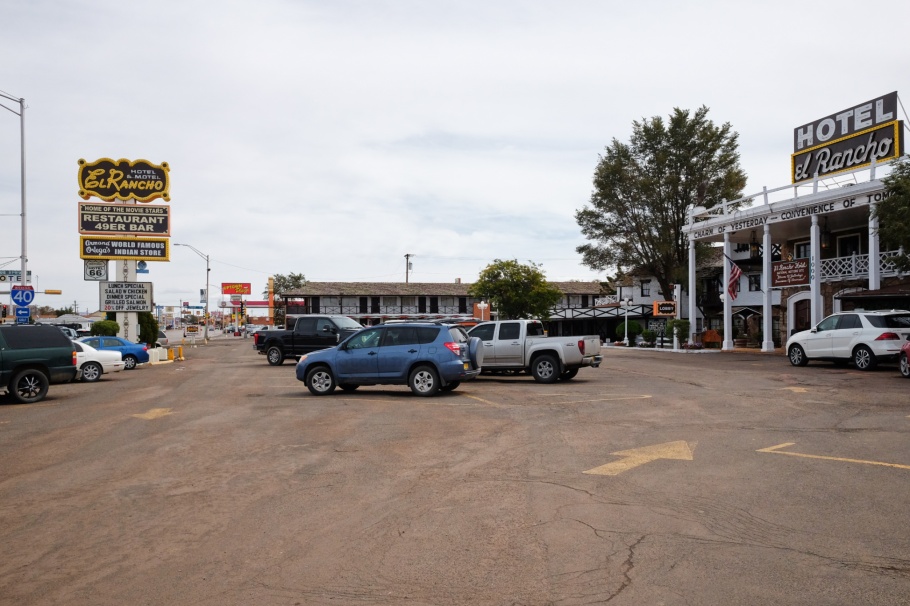
“El Rrrrrrancho: Charm of Yesterday, Convenience of Tomorrow”.
Petrified Forest National Park, AZ
At our next stop, I thought we might spend an hour or two at most. We departed the area a full four hours later, happy for the mistaken assessment. A complete drive through the Petrified Forest National Park is about 45 minutes non-stop, but there are plenty of stops. Including the national historic landmark Painted Desert Inn, the Painted Desert provides a bounty of reds, browns, oranges, blues, greens, and purples in the sandstone rock formations. Further to the south are remnants of petrified wood as brightly coloured stone logs collected together by old river systems and scattered throughout the landscape. The ages of the coloured rocks and stone logs are over 200 million years. Another extra bonus is this is the only place in the country where US-66 intersects with a national park.
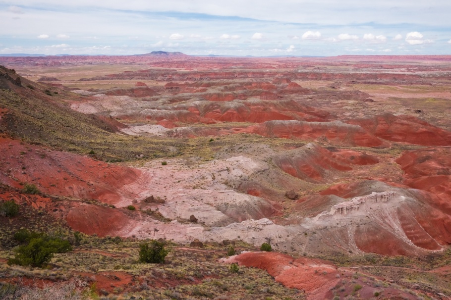
Painted Desert, from Kachina Point.
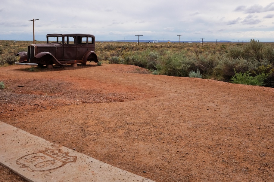
With a rusting Studebaker to the side, the poles in the background trace the former path of US-66; visible behind the poles is traffic on highway I-40.
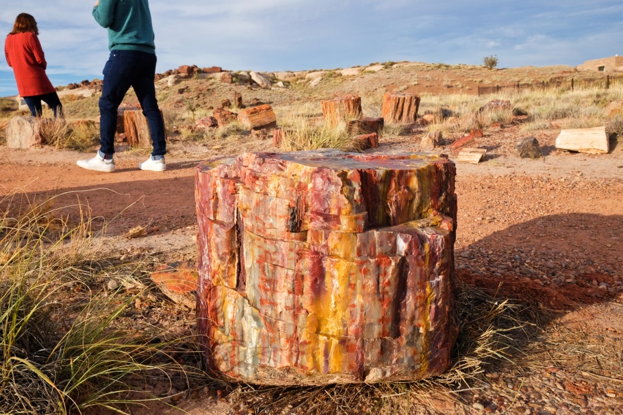
Giant petrified logs, Rainbow Forest.
Holbrook, AZ
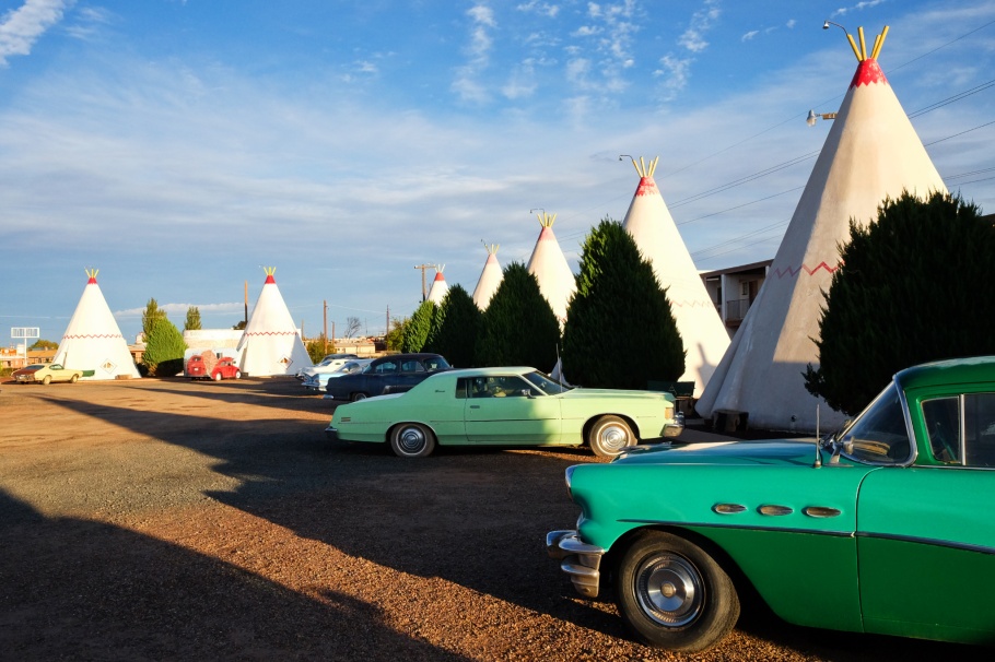
Heading west from the park’s southern entrance, it’s a short 31-kilometre (19 mile) drive to Holbrook with a first sighting of the Little Colorado River. It’s well into the afternoon when we arrive in town. We can’t spend as much time in town, but we make one stop at the famous and picturesque Wigwam Motel. I think the commercial symbolism is an anachronism, but present-day management continue to operate their vision of American nostalgia along US-66.
Late-afternoon light, yearning for a time long past.
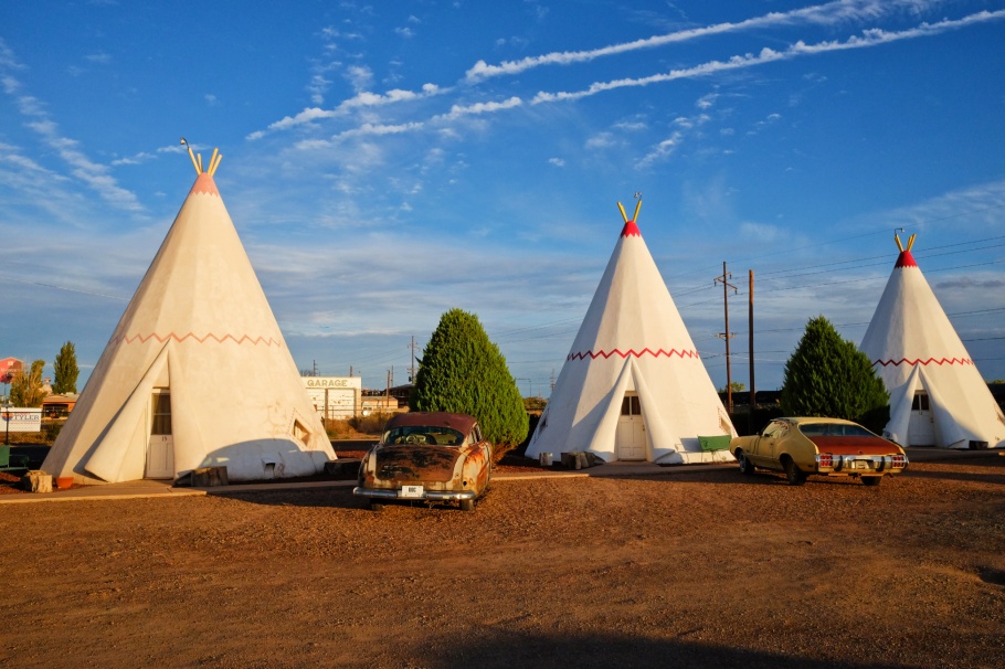
Wigwam Motel.
Winslow, AZ
The course of the Little Colorado River parallels with I-40 until our arrival in Winslow, where we head straight for a piece of history encompassing town, rail, and hospitality. The town’s La Posada Hotel was one of the last hotels for the ATSF Railway and was one of the most luxurious hotels on US-66; “posada” is Spanish for “inn” or “guest house.” The hotel was completed in 1930 and considered one of Mary Colter’s architectural masterpieces. In town at the corner of North Kinsley Avenue and West Second Street is a direct artistic reference to the Eagles’ 1972 song “Take It Easy”:
Well, I’m a-standing on a corner
In Winslow, Arizona
Such a fine sight to see
It’s a girl, my Lord
In a flat-bed Ford
Slowin’ down to take a look at me
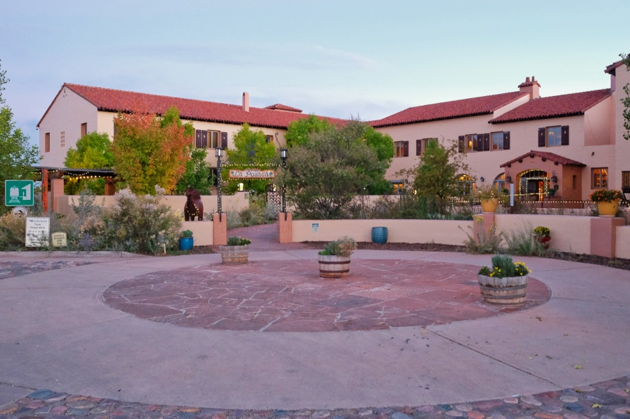
Front entrance, La Posada Hotel.
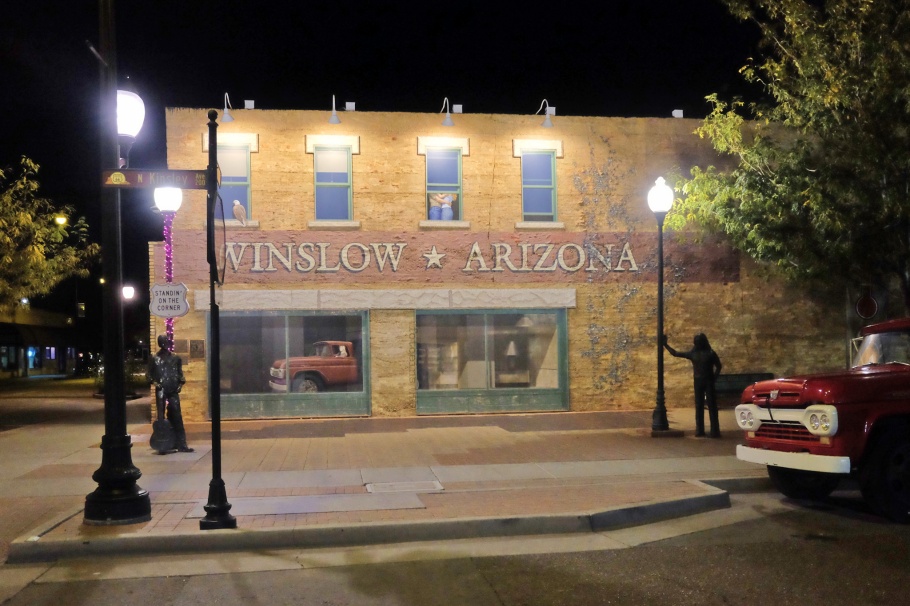
N Kinsley Ave. & W 2nd St.: there’s someone standing at the corner, next to a red Ford flat-bed truck.
Flagstaff, AZ
Central to many nature locations and geological formations in the area, Flagstaff provided a convenient “stop point” to begin our exploration of the Grand Canyon’s North Rim and South Rim. The city is also one of Arizona’s largest communities related to US-66 history and legacy. The heritage landmark 1926 ATSF railroad depot building is located just east of the present-day building housing the Amtrak station and the city’s Visitor Center. A 2013 mural by Mural Mice depicts the city’s history with US-66 is on the back wall of Lumberyard Brewing, located one block south of both railway depot and current US-66 alignment.
We also got great tips to eat at Satchmo’s and at Galaxy Diner.
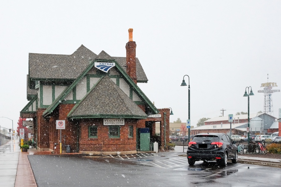
Partly obscured under early-autumn snowfall is the historic railroad district at left and the Downtowner Motel tower sign at right (16 Oct 2018).
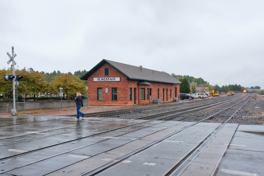
Shown above is the 1926 ATSF railroad depot building, located east of the Amtrak station (16 Oct 2018).
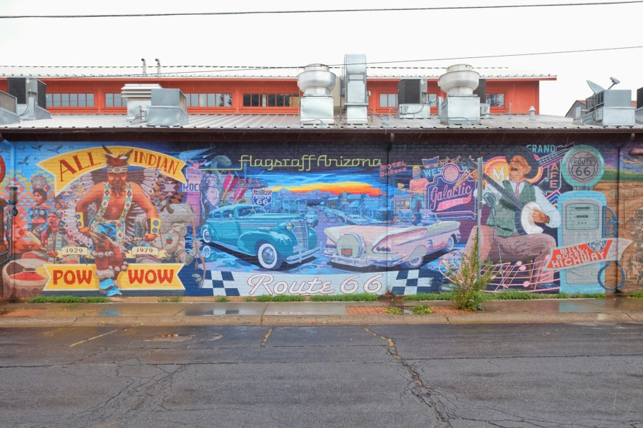
Central section of block-long mural 2013 mural “Mother Myth of Route 66”, by Mural Mice (16 Oct 2018).
I made all pictures with a Fujifilm X70 fixed-lens prime on 9, 12, and 16 October 2018. Thanks to AB for making this memorable trip possible. This post appears on Fotoeins Fotografie at fotoeins DOT com as https://wp.me/p1BIdT-eGx.

20 Responses to “1-day drive, US: Santa Fe to Flagstaff”
That’s a beautiful trip, I enjoyed the virtual journey of yours.
LikeLiked by 1 person
Hi and thanks, Cornelia. It’s fair to say I’d like to go back and drive through parts of Arizona and New Mexico.
LikeLiked by 1 person
Thanks for the tip on the murals at Flagstaff and Gallup. I make the trip between Albuquerque and the Phoenix Metro at least twice a year and always looking for photo ops along the way. By the way, the next time you have a chance, breakfast at La Posada is a real treat.
LikeLiked by 1 person
Hi, John, and you’re very welcome. Flagstaff’s “Old Town” was a lot of fun to walk through and photograph, despite the chilly snowy day while we were in town. I’d like to go back and see some more, especially under clear skies. Gallup’s street- and courthouse-murals as well as the region’s proud history of Navajo Code Talkers are a fun way to spend the day in town; I’d like to go back and spend a night at El Rancho. I also would like to go back and spend a separate night (at least) in each of Holbrook and Winslow. The novelty of Wigwam Inn and La Posada, respectively, are attractions. How do you usually make the ABQ-PHX drive: I guess it’s fastest to drive I-40 west to Flagstaff, then I-17 south. Thanks for your comment and for stopping by!
LikeLike
We usually go via Flagstaff unless there is bad weather here on that route. Then we go south and pick up I-10. That adds a couple hours or so.
LikeLiked by 1 person
Hi, John. Yes, that makes sense. I asked because there doesn’t seem to be obvious shortcuts between ABQ and PHX, especially because of mountains in west-central New Mexico to east-central Arizona. I’ll have a post about it in the future, but our “return” drive from Tucson to Santa Fe on AZ-77/US-60/I-25 was scenic and fun, but it was definitely not a “quick” drive. Up side is US-60 about which I’ll always have fond memories, especially with the stop in Pie Town.
LikeLiked by 1 person
Yes, we have only taken that route a couple of times, but it is a scenic drive, for sure.
LikeLiked by 1 person
[…] Tanner’s Crossing Bridge over the Little Colorado River; we encountered the river previously between Holbrook and Winslow. From Cameron, the stretch of land north towards Marble Canyon is entirely within the western […]
LikeLike
[…] “Mother Myth of Route 66”, 2013 mural by Mural Mice: Flagstaff, AZ – 16 Oct 2018 (X70). […]
LikeLike
[…] and the Grand Canyon; we had already crossed the Little Colorado River in the Painted Desert on a previous 1-day drive. Squeezed between the Coconino Plateau and the river’s upper gorge where the canyon is deep […]
LikeLike
[…] stopped in Gallup, New Mexico, for a few hours on our 1-day drive from Santa Fe west to Flagstaff. Only 35 kilometres (22 miles) from the New Mexico-Arizona border, Gallup is considered an […]
LikeLike
[…] stopped in Gallup, New Mexico, for a few hours on our 1-day drive from Santa Fe west to Flagstaff. Only 35 kilometres (22 miles) from the New Mexico-Arizona border, Gallup is considered an […]
LikeLike
[…] our 1-day drive from Santa Fe west to Flagstaff, we stopped in Gallup, New Mexico for a few hours. Only 35 kilometres (22 miles) from the New […]
LikeLike
[…] our 1-day drive from Santa Fe west to Flagstaff, we stopped in Gallup, New Mexico for a few hours. Only 35 kilometres (22 miles) from the New […]
LikeLike
Such a nice road trip! I could see my family doing this trip. I showed my kids the pictures and the Wigwam Hotel caught their attention. 🙂
LikeLiked by 1 person
If your family returns to the southwest U.S., there will be no shortage of interesting things to see for young and old. I’ve already posted a number of 1-day drives. I’d like to drive further east on I-40 (to roughly parallel US-66) into Texas and towards Amarillo: there’s the Midpoint Cafe in Adrian, and the Cadillac Ranch, outside of Amarillo. Thanks for your comment, Amor!
LikeLiked by 1 person
That would be another interesting road trip, out in the desert. I hope the covid situation there improves so that it’s safer to travel around there, right?
LikeLiked by 1 person
Yes, that’s true. I’d like to go back into the American Southwest, too.
LikeLiked by 1 person
[…] Our west-east crossing of the Divide on US-60 complements our east-west crossing of the Divide on I-40 one week earlier (on day 8) when we stopped in the town of Continental Divide, NM. […]
LikeLike
[…] Santa Fe to Flagstaff […]
LikeLike