1-day drive, US: Flagstaff to Vermilion Cliffs
Above/featured: Vermilion Cliffs loom over the new and old Navajo Bridge at left and right, respectively (X70).
The following takes place on the first half of travel day 10 in the American Southwest. From Flagstaff, we’re heading north on highway US-89, past Cameron, through the northern limit of the Painted Desert, and next to the Echo Cliffs. At Bitter Springs, the highway splits, and we head northwest on US-89A to Marble Canyon, where Navajo Bridge crosses over the Colorado River. The highway continues west into the Arizona Strip, below Vermilion Cliffs, past Cliff Dwellers, and into House Rock Valley.
Along US-89 and US-89A
- Cameron
- Echo Cliffs
- Bitter Springs
- “Dreamcatchers”
- Navajo Bridge (Marble Canyon)
- Vermilion Cliffs
- House Rock Valley Overlook
Cameron
About an hour outside of Flagstaff, Cameron is a convenient stop to stretch our legs, and, if necessary, to fuel up on snacks for the humans and gasoline for the vehicles. Now closed, we can still enjoy a view of the 1911 Tanner’s Crossing Bridge over the Little Colorado River; we encountered the river previously between Holbrook and Winslow. From Cameron, the stretch of land north towards Marble Canyon is entirely within the western border of the Navajo nation. Visitors to Cameron have many options: drive west into the Grand Canyon, northeast Arizona via Tuba City, east into Hopi lands, or north as we set out for Marble Canyon.

Tanner’s Crossing over the Little Colorado River (X70).

Little Colorado River, facing west (X70).

Cameron Trading Post (X70).
Echo Cliffs
Continuing north past the turnoff for Tuba City, a vertical wall of rock starts approaching from the right until we’re hugging the cliffs at its feet. Highway US-89 parallels the old Honeymoon Historic Trail at the foot of Echo Cliffs. We can’t help ourselves, and stop at a couple of places along the road to enjoy the view; we imagine a time long before highways and travelling these trails between Utah and Arizona on horseback or by stagecoach, a time where seemingly immovable rock has witnessed people come and go. Echo Cliffs define the western limit of the Kaibito Plateau stretching up and beyond to the east. Between Cameron and Marble Canyon, one of the few places for fuel along US-89A is at the town of “The Gap” (US-89 mile marker 498) where Navajo Route N20 begins.

Echo Cliffs, from US-89 between mile markers 515 and 516 (X70).

Northbound on US-89, between mile markers 515 and 516: Echo Cliffs at right, Vermilion Cliffs at left-background (X70).
Bitter Springs
The small town of Bitter Springs is the junction of US-89 and US-89A. Near the junction is a Mormon church, highlighting the long history in the American Southwest of Mormon settlement and their travels along the Honeymoon Historic Trail, a long arduous route used by Mormon couples in Arizona from about the 1880s to 1930s to reach the nearest temple in St. George, Utah, and “seal” their marriage vows. The old trail runs parallel with the Fredonia-Vermilion Cliffs Scenic Road (ADOT) on US-89A, heading northwest towards Marble Canyon and ending at the town of Fredonia in north-central Arizona.

Facing north “above” the US-89/89A junction, with a Mormon church and Echo Cliffs in the foreground and background, respectively (X70).
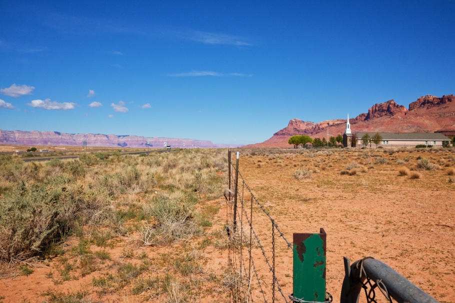
Facing north “above” the US-89/89A junction: Vermilion Cliffs in the distance at left; a Mormon church and Echo Cliffs are at right in the foreground and background, respectively (X70).

Facing west to other houses in town; Vermilion Cliffs at right (X70).
“Dreamcatchers”
On US-89A just before arriving at Navajo Bridge, we came across this empty stand. I was attracted by the location and labeling; then subsequently mesmerized by the sense of scale and separation against the Vermilion Cliffs and the blue sky. We don’t find any signs of small hoops of indigenous origins, but this scene definitively encapsulates the culmination of a long-held desire to see this part of the world.

Closed stand, open attitude (X70).
Navajo Bridge (Marble Canyon)
The 1929 bridge over the Colorado River at this location provided much faster travel connections between southern Utah with north and east Arizona through the Arizona Strip. Before construction, the area of land called the Arizona Strip was cut off by the Colorado River and the Grand Canyon, and travel between Utah and Arizona was either the “long way around” between Kanab and Page, or alternatively, one could follow the arduous Honeymoon Trail route and crossing the Colorado River at Lee’s Ferry. Until the bridge’s construction, Lee’s Ferry was the only crossing over the Colorado River over a stretch of 960 kilometres (600 miles).
Arriving from the south on US-89A, Navajo Bridge provides the first sign for the town of Marble Canyon, and marks the boundary for the Glen Canyon Recreation Area to the northeast and the Grand Canyon National Park to the southwest. With the new bridge replacement opening in 1995, the old bridge is now pedestrian-only as historical monument and viewpoint over the Colorado River and to the surrounding cliffs. The accompanying Navajo Bridge Interpretive Center provides additional context to the area’s geography and history and the people who settled here.

Navajo Bridge, 1st (pedestrian) and 2nd (vehicular): facing southeast (X70).

Navajo Bridge, 2nd and vehicular bridge: facing northwest (X70).

Facing northeast and upstream on the Colorado River, from 1st Navajo Bridge. The bridge marks the southern limit to the Glen Canyon Recreation Area (X70).
Vermilion Cliffs
Like a large red wall, the escarpment looms to heights over 600 metres (2000 feet) above the road surface. The Vermilion Cliffs define the edge of the Paria Plateau, a part of the Vermilion-Cliffs National Monument. These cliffs are located at the lower end of a gigantic geologic formation called “The Grand Staircase”, which begins roughly with the Grand Canyon to the south and ascending north to the steep cliffs in Utah. I think it’s best to view the deep reds of the Vermilion Cliffs against clear blue skies around midday with the cliffs under front-illumination by the sun almost due south.

Vermilion Cliffs, facing north (6D1).

East to Vermilion Cliffs at left, highway US-89A at right, and Echo Cliffs in the background (6D1).
House Rock Valley Overlook
Highway US-89A begins climbing the Kaibab Plateau with an increasing presence of trees, a stark contrast against the arid treeless landscape behind us. We stop at an overlook, providing a view of House Rock Valley and one last look at Vermilion Cliffs and Echo Cliffs. The cliffs emphasize the “edge” to a geographical formation that extends much farther than what we can see, sparking the obvious question: what is there over and beyond the edge?
For the remainder of the day’s drive, we continue to ascend the plateau towards Jacob Lake, where we turn south onto state highway AZ-67 towards the North Rim of the Grand Canyon.
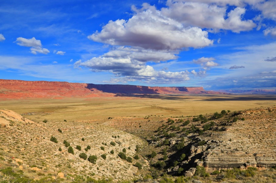
East-northeast to Vermilion Cliffs, House Rock Valley with US-89A visible as a diagonal line, and Echo Cliffs in the distance at right (6D1).
I made all pictures above on 13 October 2018 with a Canon EOS6D mark 1 (6D1) and a Fujifilm X70 fixed-lens prime (X70). Thanks to AB for making this memorable trip possible. This post appears on Fotoeins Fotografie at fotoeins DOT com as https://wp.me/p1BIdT-f2J.
PostScript: After driving the “southern” Fredonia-Vermilion Cliffs Scenic Road, I’m fascinated by the routes provided by US-89 and US-89A, which encircle the Paria Plateau between Kanab, UT and Bitter Springs, AZ. That is to say, I’m eager to complete this “circle route” in the future.

11 Responses to “1-day drive, US: Flagstaff to Vermilion Cliffs”
[…] spent three days in October 2018 exploring parts of the Grand Canyon National Park. After our drive from Flagstaff to Vermilion Cliffs, we pushed forward to the North Rim and the winding scenic drive took us to Point Imperial and Cape […]
LikeLike
[…] Flagstaff to Vermilion Cliffs […]
LikeLike
[…] Flagstaff to Vermilion Cliffs […]
LikeLike
[…] Flagstaff to Vermilion Cliffs […]
LikeLike
I really enjoyed your very interesting and informative post, Henry. Thank you for sharing with us.
LikeLiked by 1 person
Hi and thanks, Cornelia. I hope the words and images provide further impetus for your visit(s) to the American Southwest in the near future.
LikeLiked by 1 person
[…] Flagstaff to Vermilion Cliffs […]
LikeLike
[…] through the American Southwest. Day 9 was a long one on the road: from Flagstaff, we drove north on US-89 and US-89A next to Echo Cliffs and Vermilion Cliffs, and ending up at North Rim for our first-ever visit to […]
LikeLike
[…] Flagstaff to Vermilion Cliffs, and on the same day, Grand Canyon’s North Rim […]
LikeLike
[…] Overlook onto House Rock Valley & Vermilion Cliffs – 13 Oct 2018 (6D1). […]
LikeLike
[…] highway US-89A, between mile markers 527 and 528 in northern Arizona; Vermilion Cliffs and Echo Cliffs at centre […]
LikeLike