Fotoeins Fotografie

location bifurcation, place vs. home

Posts from the ‘Mountains’ category

Cerro Tololo Interamerican Observatory, CTIO, Cerro Tololo, Región de Coquimbo, Chile, fotoeins.com

Chilean Andes: morning send-off with Atacama minions

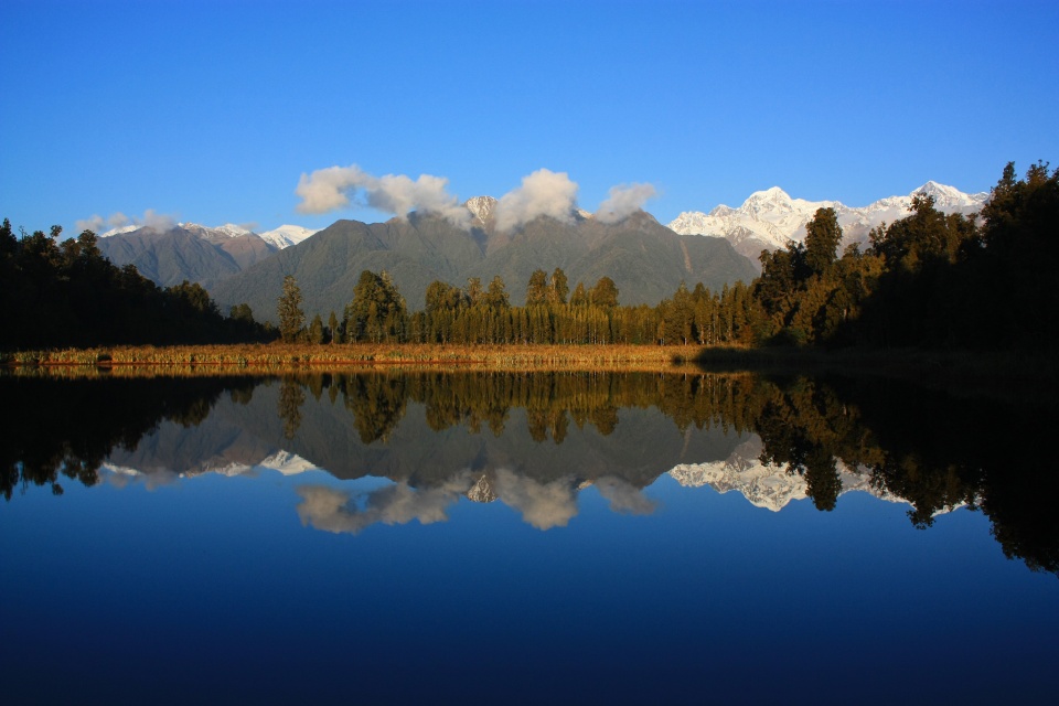
Above/featured: Morning fog in the valleys below, facing north-northeast from Cerro Tololo Observatory – 9am CLDT (12pm UTC), 22 Sept 2011.

Late-2011: Cerro Tololo Observatory, Región de Coquimbo, Chile.

The morning creeps gently forward, up and over the desert sky. Sounds? What sounds? What scarce sounds there are, they pierce the silence with soft whistles and drawn-out wails. Alternating light and dark horizontal streamers, known also as “the rays of God,” mark the first light of dawn. Small clumps break loose, as the overnight shroud of valley fog pulls back slowly from view.

The sun climbs higher, the shadows grow shorter, the cotton patch dissolves. It isn’t long until a spectacular sight is revealed. This is what you get from a height of 7500 feet above sea level.

Dry river beds twist and sweep and stretch along canyon floors. Cactus and desert scrub carpets the surrounding hills in faded greens and dusty browns. To the east rise jagged rocky teeth capped with white frosting, fixing the location of the Andes along the Chilean spine.

In this desolate and isolated part of the world, I’ve often wondered about the few brave souls who make this place their home. They’re prospectors, miners, even some farmers, all of whom carry their burden for financial endeavour. People have been digging around in these parts for centuries, whether it’s plant, mineral, or some kind of monetary paydirt.

But there’s another human enterprise with different rewards, a quest that asks questions on a much larger scale.

How do planets take shape?
How do stars form?
How are galaxies assembled?
Is there life elsewhere in the universe?

These issues occupy astronomers from all over the world. Many astronomers go up onto mountains, just like this one, onto the summit of Cerro Tololo, peering into the skies. The telescopes point straight up, reaching out like outstretched hands, wanting more.

( Click here for images and more )

Up, up, and away: Helijet chopper tour over Vancouver

Fortune often favours the brave, especially for those who rarely get to see Vancouver from a height of 1500 metres (5000 feet). This city may be my birthplace, but this is my first helicopter tour. The only other occasions I’ve seen Vancouver from the air are from planes on approach to YVR international airport.

We arrive at Vancouver Helijet Heliport on a weekday morning, and hang out for a few minutes in the spacious waiting area, sipping on coffee and chatting with the folks at the front desk. We head outside, file down the walkway to the landing pad, and hop into a Bell 206L-3 LongRanger helicopter (chopper) for our 20-minute sightseeing tour.

The “West Coast Spectacular” tour heads across Burrard Inlet to the North Shore, goes up and over the nearby coastal mountains, flies past Crown Mountain and The Lions (The Sisters), before emerging over Howe Sound. It’s easy to forget this abundant B.C. evergreen wilderness is at the doorstep to Vancouver. After heading south down the Sound, the final half of the tour proceeds past West Vancouver to English Bay (Salish Sea), enters and covers False Creek, crosses over the downtown Vancouver peninsula, makes a small loop over Burrard Inlet, before landing at the harbour base. The map below shows in green the chopper’s path, the Heliport in downtown Vancouver is marked by the helicopter icon, and the blue pins indicate mountains I identified during the tour.

The scheduled 20-minute tour goes by quickly; blink or look away for a moment, and a part of that view in that moment disappears. Not surprisingly, there’s not a lot of chatter throughout the flight, and we’re astonished by what we’re seeing below. After returning to base, we rediscover our voices and express our wonder with grateful enthusiasm. Helijet’s sightseeing tours go for a pretty penny; the “West Coast Spectacular” tour costs $224 CAD per person (minimum of two people, 2014), but the price goes down to about $150 per person for a group of five. These photos show there’s a different side to Vancouver that’s tantalizingly close and within reach.

( Click here for more )

New Zealand: inside Fiordland’s Milford Sound

A trip to New Zealand’s South Island is incomplete without a visit to the Fiordland National Park. A stop at one or both of Milford Sound or Doubtful Sound is also highly recommended, as they are some of the most popular destinations in New Zealand and on the South Island. From Queenstown, I sided with Real Journeys for a daytrip out to Milford Sound: morning coach on the only road access, Milford Sound Highway (State Highway 94), from Queenstown to Milford Sound; a boat into the fiord; and the return to Queenstown by plane. The Maori Ngai Tahu name for the body of water is Piopiotahi (“one piopio bird”). The piopio resembles a thrush but is considered extinct with the last sighting in 1905.

Much of the scenery reminds me of my home province: coastal British Columbia. Carved by glacial activity, Fjords (also spelled “fiords”) are long narrow inlets with steep sides or cliffs. My time in southwest New Zealand reminds me of home along the southwest coast of British Columbia.

( Click here for images and more )

New Zealand: Air Safaris’ Grand Traverse flight over the Southern Alps

The majestic mountain spine along New Zealand’s South Island is known as “The Southern Alps”; the Maori Ngai Tahu name for these mountains is “kā tiritiri o te moana”. For many locations around the South Island, you cannot avoid or ignore the sight of looming towers of rock and snow.

Between visits to the Franz Josef Glacier and Fox Glacier, I’d been thinking about whether or not I should have a look at the mountains from above. It would be beautiful, but it also seemed very expensive. What to do, what to do … it sounds stupid writing it out now, but a unique opportunity had presented itself, and I knew I’d have deep regrets if I didn’t take it.

I bit the proverbial bullet and hopped onto a plane with Air Safaris for a 50-minute “The Grand Traverse” tour including aerial views of various glaciers, Horokoau (Mount Tasman), and Aoraki (Mount Cook).


( Click here for images and more )

Lake Matheson, Westland National Park, West Coast, South Island, New Zealand, fotoeins.com

New Zealand: Lake Matheson & the southern Alps at sunset

Rewards go to the patient, especially those on daytime walks through the temperate rainforest to the Franz Josef Glacier and the Fox Glacier.

After all, this area is a UNESCO World Heritage Site.

After my visit to Fox Glacier earlier in the day, I arranged for a short 10-minute shuttle from Fox Glacier town to Lake Matheson (Te Ara Kairaumati) before sunset. Even in winter’s low-season, I was surprised by how few people were around to enjoy the view.

The sequence of photos below span a period of just over one hour in time. Appearing in most of the photos are the two grand snow-frosted peaks: Mount Tasman (Horokoau) on the left and Aoraki (Mount Cook) on the right.

( Click here for more )