New Zealand: Air Safaris’ Grand Traverse flight over the Southern Alps
The majestic mountain spine along New Zealand’s South Island is known as “The Southern Alps”; the Maori Ngai Tahu name for these mountains is “kā tiritiri o te moana”. For many locations around the South Island, you cannot avoid or ignore the sight of looming towers of rock and snow.
Between visits to the Franz Josef Glacier and Fox Glacier, I’d been thinking about whether or not I should have a look at the mountains from above. It would be beautiful, but it also seemed very expensive. What to do, what to do … it sounds stupid writing it out now, but a unique opportunity had presented itself, and I knew I’d have deep regrets if I didn’t take it.
I bit the proverbial bullet and hopped onto a plane with Air Safaris for a 50-minute “The Grand Traverse” tour including aerial views of various glaciers, Horokoau (Mount Tasman), and Aoraki (Mount Cook).
Air Safaris’ The Grand Traverse

Waiho River Valley, shortly after departure from Franz Josef Aerodrome.

Fox Glacier Township (lower-left), Cook River (Weheka) exits to the Tasman Sea (upper-right).

Fox Glacier.

Fox Glacier.
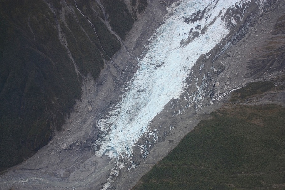
Fox Glacier: terminal moraine.

Midway up Fox Glacier.

Fox Glacier: down from the neve.

Neve at the top of Fox Glacier.
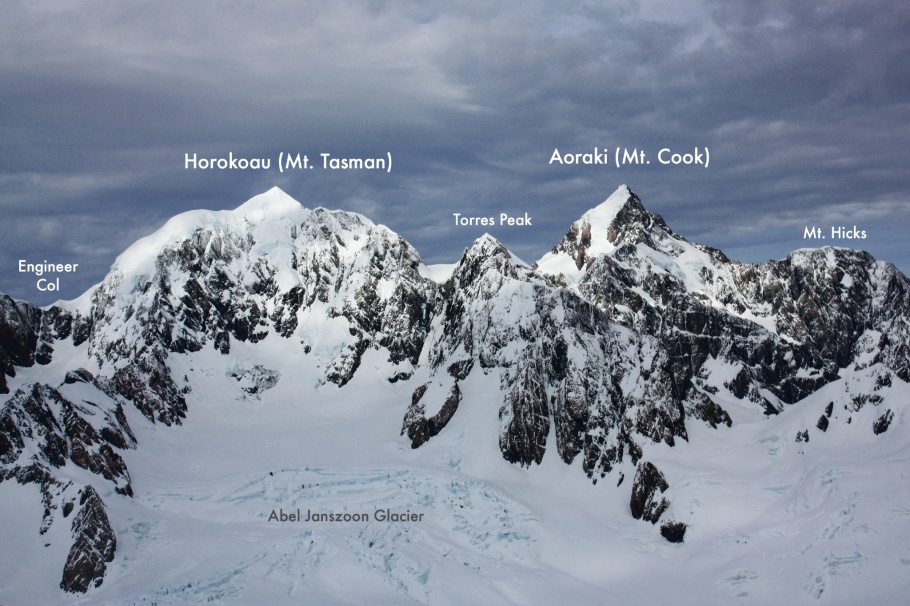
South to Horokoau and Aoraki, at flight altitude about 3 km.
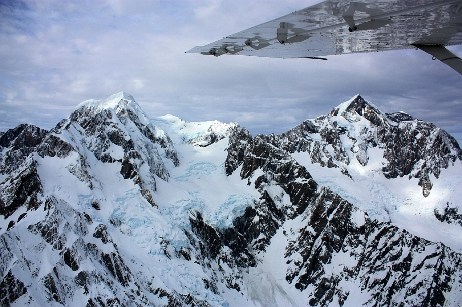
Left: Mount Tasman (Horokoau); right: Aoraki (Mount Cook).

Mount Sefton.

South from Tasman Glacier (foreground) to Tasman River and Lake Pukaki (background).

Aoraki (Mount Cook): reach out and touch.
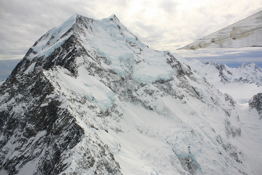
Aoraki (Mount Cook): so close.
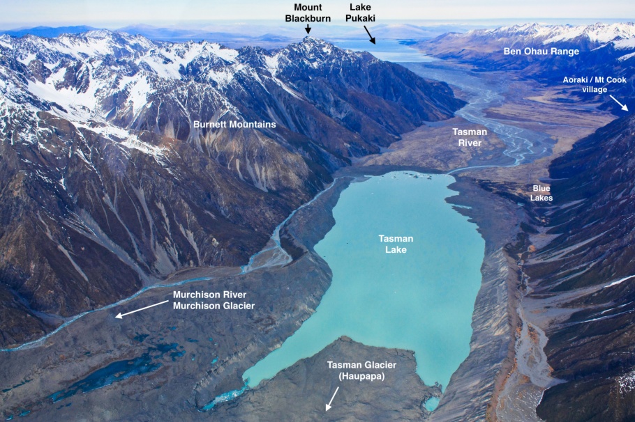
Melt products from the Tasman Glacier stream into Tasman Lake, from which begins the Tasman River, flowing further south into Lake Pukaki.

East face of Mount Cook (Aoraki); at centre-right are the Grand Plateau & Hochstetter Glacier. (foreground)

Malte Brun Range (left), top of Tasman Glacier (center).

Upper reaches of Tasman Glacier, with Mt. Elie de Beaumont at upper-right.

Godley River valley

Godley River: upper reach to Godley Glacier; fed also by Fitzgerald and Separation Streams

Tasman Saddle Hut (NZ).
Transverse crevasses at the neve, Franz Josef Glacier

Looking down Franz Josef Glacier

Down to terminal moraine, river valley

Transverse crossover and up along the medial moraine, Franz Josef Glacier

Last glance from the air, Franz Josef Glacier

Westward: Waiho River, Waiho River Bailey Bridge (lower-centre), Waiho Loop.

Westward: edge of the Waiho Loop, and Waiho River meets the Tasman Sea (upper left).

Waiho River Bailey Bridge; see earlier post on Franz Josef Glacier. Update, 26 Mar 2019: heavy rains washes away this bridge (NZ Herald).

Final look east towards Franz Josef, on approach to the Aerodrome.

End of The Grand Traverse, Franz Josef Aerodrome
More
• The slow approach to Franz Josef Glacier
• The slow forest walk to Fox Glacier
• Lake Matheson and the southern Alps at sunset
• Swollen Waiho from heavy early-autumn rains washes away Waiho Bridge: NZ Herald, 26 Mar 2019.
I made the photos above on 21 July 2012. This post appears on Fotoeins Fotografie at fotoeins DOT com as http://wp.me/p1BIdT-292. I received no compensation for writing this content.

14 Responses to “New Zealand: Air Safaris’ Grand Traverse flight over the Southern Alps”
Breathtaking views!… I can totally see how this country became middle earth.
LikeLiked by 1 person
Hi, Eva. Thank you, but I have to say that while the view overhead was spectacular, the view from any vantage point high or low on the South Island on a clear day is breathtaking. Really, it was all very addictive, because everywhere I went, I kept wanting more: I always wanted something different, a view or an angle, of the Southern Alps. I really do love the country, especially the South Island. What’s more: there’s lots on the South Island I didn’t see, and there’s a ton on the North Island I didn’t have a chance to see. 🙂
Thanks again for reading and for your comment!
LikeLike
[…] Pin M in the map below marks the location of Lake Matheson. The remaining pins indicate walks to Fox Glacier (pins C,D) and Franz Josef Glacier (pins A,B). The red line traces the approximate path of the flying tour with The Grand Traverse over the Southern Alps. […]
LikeLike
[…] slow forest walk to Fox Glacier : green path marked by pins C and D in the map above. • The Grand Traverse over the Southern Alps : shown as a thick red line in the map […]
LikeLike
[…] The slow approach to Franz Josef Glacier • The Grand Traverse over New Zealand’s Southern Alps • Sounds of a sunset on New Zealand’s South Island • Lake Matheson […]
LikeLike
[…] The Grand Traverse over New Zealand’s Southern Alps • Sounds of a sunset on New Zealand’s South Island • Lake Matheson […]
LikeLike
[…] Lake Matheson: What are the sounds of a New Zealand sunset? • Southern Alps: Flying over the South Island’s Southern Alps • Southern Alps: The Southern Alps at sunset, from Lake Matheson • Train: […]
LikeLike
[…] Tasman Lake (lower centre) from which the river flows into Lake Pukaki (upper centre) – 21 Jul 2012 […]
LikeLike
[…] Flying north and facing west to the 1st and 2nd highest peaks in New Zealand (HL 20120721; see also post on the “Grand Traverse”). […]
LikeLike
[…] visual account of the circular flight over southwest New Zealand can be seen here. The west coast on the nation’s South Island is a UNESCO World Heritage Site since […]
LikeLike
[…] Lake Matheson: What are the sounds of a New Zealand sunset? • Southern Alps: Flying over the South Island’s Southern Alps • Southern Alps: The Southern Alps at sunset, from Lake Matheson • Train: […]
LikeLike
[…] Fly over the Southern Alps and the country’s two tallest mountains – 21 July 2012. […]
LikeLike
[…] Tasman Lake, Tasman River, and beyond to Lake Pukaki (HL). […]
LikeLike
[…] Fly over the Southern Alps and the country’s two tallest mountains – 21 July 2012. […]
LikeLike