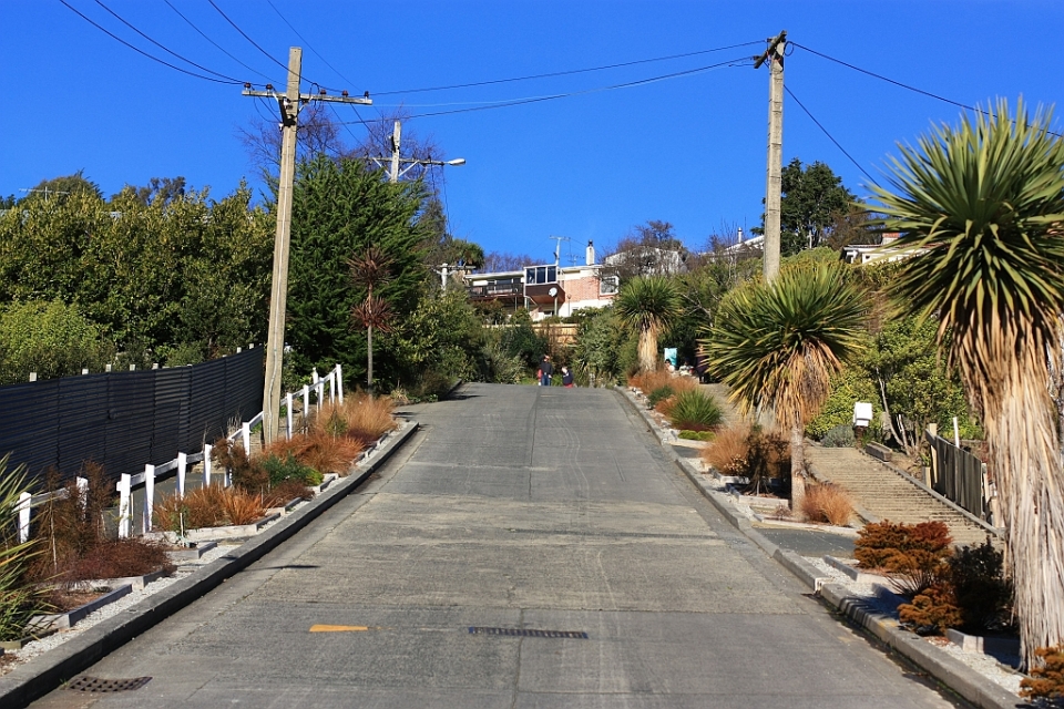
Fotoeins Fotografie

location bifurcation, place vs. home

Posts tagged ‘Te Waka o Aoraki’

Milford Sound, Piopiotahi, Fiordland National Park, Te Moana o Atawhenua, Southland, South Island, Te Wahipounamu, Te Wai Pounamu, Te Waipounamu, Te Waka a Maui, Te Waka o Aoraki, New Zealand, Aotearoa,

Fotoeins Friday: RTW10, thirty-one

10 years ago, I began an around-the-world (RTW) journey lasting 389 consecutive days, from 24 December 2011 to 15 January 2013 inclusive.

25 July 2012.

Like many before me, I’ve purchased a package for a daytrip on New Zealand’s South Island. After a 5-hour ride from Queenstown on a large comfortable coach/bus, we arrive at Milford Sound (Piopiotahi) and hop onto a 2-hour cruise into the waters of the Fiordland (Te Moana o Atawhenua). Pyramid-shaped frosted mountain peaks, steep cliffs, tall waterfalls, and deep fjords are the common sight; another bonus comes with the arrival of dolphins swimming alongside the boat.

The highlighted geographical feature in this post is located within the UNESCO World Heritage Site “Te Wahipounamu – South West New Zealand”. I made the image on 25 Jul 2012 with a Canon EOS450D (Rebel XSi) and these settings: 1/1600-sec, f/4, ISO200, and 18mm focal length (29mm full-frame equivalent). This post appears on Fotoeins Fotografie at fotoeins DOT com as https://wp.me/p1BIdT-mgM.

Aotearoa, Ka Tiritiri o te Moana, Lake Matheson, Maori South Island, Southern Alps, Tai Poutini, Te Ara Kairaumati, Te Wahipounamu, Te Wai Pounamu, Te Waipounamu, Te Waka a Maui, Te Waka o Aoraki, UNESCO, West Coast, Westland Tai Poutini National Park, World Heritage, fotoeins.com

Fotoeins Friday: RTW10, thirty

10 years ago, I began an around-the-world (RTW) journey lasting 389 consecutive days, from 24 December 2011 to 15 January 2013 inclusive.

22 July 2012.

After spending the morning and a part of the afternoon walking to and from the Fox Glacier, I arranged for an afternoon shuttle-bus ride from the township to (and back from) Lake Matheson (Te Ara Kairaumati). The walk around the lake is not physically demanding, and at the northwest end of the lake is the viewpoint called “View of Views.” A small clearing through the trees provides a view across the lake and beyond to the nation’s two highest mountains: Mount Tasman (Horokoau) and Mount Cook (Aoraki). As it’s my only day in the area, the timing is excellent at the final light of day.

The highlighted geographical feature in this post is located within the UNESCO World Heritage Site “Te Wahipounamu – South West New Zealand”. I made the image on 22 Jul 2012 with a Canon EOS450D (Rebel XSi) and these settings: 1/160-sec, f/4.5, ISO400, and 34mm focal length (54mm full-frame equivalent). This post appears on Fotoeins Fotografie at fotoeins DOT com as https://wp.me/p1BIdT-mgJ.

Franz Josef Glacier, Westland National Park, South Island, New Zealand, Aotearoa, fotoeins.com

Fotoeins Friday: RTW10, twenty-nine

10 years ago, I began an around-the-world (RTW) journey lasting 389 consecutive days, from 24 December 2011 to 15 January 2013 inclusive.

20 July 2012.

On New Zealand’s South Island, two glaciers have unusual attributes by comparison to other glaciers around the world: they’re presently located adjacent to a temperate rainforest, and they’re both accessible on foot and with personal vehicle. One of these glaciers has the Māori name “Kā Roimata o Hine Hukatere” for “the tears of Hine Hukatere”, after a tragic story passed by oral tradition from one generation to the next. The colonizers’ name is the Franz Josef Glacier, named in 1865 by German geologist Julius von Haast after the Austrian emperor of the time.

In the image here, I’m standing next to a massive terminal moraine just out of frame at right. This is the safe and “nearest” viewpoint, about 0.5 km from the head of the receding glacier. The glacier melt is responsible for the Waiho river, whose initial flow is marked by the diagonal line of rocks towards the lower left. Poor “stick people”! You can read more about my daytrip to the Franz Josef Glacier.

The highlighted geographical feature in this post is located within the UNESCO World Heritage Site “Te Wahipounamu – South West New Zealand”. I made the image on 20 Jul 2012 with a Canon EOS450D (Rebel XSi) and these settings: 1/1600-sec, f/4, ISO100, and 25mm focal length (40mm full-frame equivalent). This post appears on Fotoeins Fotografie at fotoeins DOT com as https://wp.me/p1BIdT-mez.

Seaward Kaikoura mountain range, on KiwiRail Coastal Pacific train, Picton to Christchurch, South Island, New Zealand, fotoeins.com

Fotoeins Friday: RTW10, twenty-eight

10 years ago, I began an around-the-world (RTW) journey lasting 389 consecutive days, from 24 December 2011 to 15 January 2013 inclusive.

14 July 2012.

It’s the slow measured surface journey from Wellington to Christchurch. After the morning passage across Cook Strait to Picton, I hop on board Kiwi Rail’s Coastal Pacific for the southbound train along the South Island’s east coast. The train includes covered open-air cars for a very breezy view of the surrounding landscape. Shortly before arrival in Kaikoura, I look back to the northwest for a view of the mountains in the Seaward Kaikoura Range; these mountains are considered the northern tip of the Southern Alps (Kā Tiritiri o te Moana).

I made the image on 14 Jul 2012 with a Canon EOS450D (Rebel XSi) and these settings: 1/400-sec, f/4.5, ISO400, and 30mm focal length (48mm full-frame equivalent). This post appears on Fotoeins Fotografie at fotoeins DOT com as https://wp.me/p1BIdT-mei.

Alhambra-Union Rugby Football Club, North Ground, rugby, rugby union, Dunedin, Otago, South Island, New Zealand, Aotearoa, myRTW, fotoeins.com

Fotoeins Friday: Otago rugby, Dunedin North Ground

28 July 2012.

Over the duration of a year-long journey around the world, I’m spending significant time in the southern hemisphere (not unlike five previous years working and living in Chile). The time has also meant I’ve come to learn about cricket and rugby, which are important to Australia, New Zealand, and South Africa. I was introduced to rugby league years ago, but I prefer rugby union, especially after having watched on television games during the 2011 Rugby World Cup.

On foot north from Dunedin CBD centre to Baldwin Street, I pass by the city’s North Ground, home to the Alhambra-Union Rugby Football Club. I stop to watch one of the Club’s junior sides, Colts, in an afternoon rugby game in progress where this “line-out” takes place.


During my year-long RTW, I made this photo on 28 July 2012 with the Canon 450D, 50-prime, and the following settings: 1/250-sec, f/5, ISO100, and 50mm focal length (80mm full-frame equivalent). This post appears on Fotoeins Fotografie at fotoeins.com as http://wp.me/p1BIdT-9ZA.