Fotoeins Fotografie

location bifurcation, place & home

Posts tagged ‘Southern Alps’

Aotearoa, Ka Tiritiri o te Moana, Lake Matheson, Maori South Island, Southern Alps, Tai Poutini, Te Ara Kairaumati, Te Wahipounamu, Te Wai Pounamu, Te Waipounamu, Te Waka a Maui, Te Waka o Aoraki, UNESCO, West Coast, Westland Tai Poutini National Park, World Heritage, fotoeins.com

Fotoeins Friday: RTW10, thirty

10 years ago, I began an around-the-world (RTW) journey lasting 389 consecutive days, from 24 December 2011 to 15 January 2013 inclusive.

22 July 2012.

After spending the morning and a part of the afternoon walking to and from the Fox Glacier, I arranged for an afternoon shuttle-bus ride from the township to (and back from) Lake Matheson (Te Ara Kairaumati). The walk around the lake is not physically demanding, and at the northwest end of the lake is the viewpoint called “View of Views.” A small clearing through the trees provides a view across the lake and beyond to the nation’s two highest mountains: Mount Tasman (Horokoau) and Mount Cook (Aoraki). As it’s my only day in the area, the timing is excellent at the final light of day.

The highlighted geographical feature in this post is located within the UNESCO World Heritage Site “Te Wahipounamu – South West New Zealand”. I made the image on 22 Jul 2012 with a Canon EOS450D (Rebel XSi) and these settings: 1/160-sec, f/4.5, ISO400, and 34mm focal length (54mm full-frame equivalent). This post appears on Fotoeins Fotografie at fotoeins DOT com as https://wp.me/p1BIdT-mgJ.

Franz Josef Glacier, Westland National Park, South Island, New Zealand, Aotearoa, fotoeins.com

Fotoeins Friday: RTW10, twenty-nine

10 years ago, I began an around-the-world (RTW) journey lasting 389 consecutive days, from 24 December 2011 to 15 January 2013 inclusive.

20 July 2012.

On New Zealand’s South Island, two glaciers have unusual attributes by comparison to other glaciers around the world: they’re presently located adjacent to a temperate rainforest, and they’re both accessible on foot and with personal vehicle. One of these glaciers has the Māori name “Kā Roimata o Hine Hukatere” for “the tears of Hine Hukatere”, after a tragic story passed by oral tradition from one generation to the next. The colonizers’ name is the Franz Josef Glacier, named in 1865 by German geologist Julius von Haast after the Austrian emperor of the time.

In the image here, I’m standing next to a massive terminal moraine just out of frame at right. This is the safe and “nearest” viewpoint, about 0.5 km from the head of the receding glacier. The glacier melt is responsible for the Waiho river, whose initial flow is marked by the diagonal line of rocks towards the lower left. Poor “stick people”! You can read more about my daytrip to the Franz Josef Glacier.

The highlighted geographical feature in this post is located within the UNESCO World Heritage Site “Te Wahipounamu – South West New Zealand”. I made the image on 20 Jul 2012 with a Canon EOS450D (Rebel XSi) and these settings: 1/1600-sec, f/4, ISO100, and 25mm focal length (40mm full-frame equivalent). This post appears on Fotoeins Fotografie at fotoeins DOT com as https://wp.me/p1BIdT-mez.

Seaward Kaikoura mountain range, on KiwiRail Coastal Pacific train, Picton to Christchurch, South Island, New Zealand, fotoeins.com

Fotoeins Friday: RTW10, twenty-eight

10 years ago, I began an around-the-world (RTW) journey lasting 389 consecutive days, from 24 December 2011 to 15 January 2013 inclusive.

14 July 2012.

It’s the slow measured surface journey from Wellington to Christchurch. After the morning passage across Cook Strait to Picton, I hop on board Kiwi Rail’s Coastal Pacific for the southbound train along the South Island’s east coast. The train includes covered open-air cars for a very breezy view of the surrounding landscape. Shortly before arrival in Kaikoura, I look back to the northwest for a view of the mountains in the Seaward Kaikoura Range; these mountains are considered the northern tip of the Southern Alps (Kā Tiritiri o te Moana).

I made the image on 14 Jul 2012 with a Canon EOS450D (Rebel XSi) and these settings: 1/400-sec, f/4.5, ISO400, and 30mm focal length (48mm full-frame equivalent). This post appears on Fotoeins Fotografie at fotoeins DOT com as https://wp.me/p1BIdT-mei.

Air Safaris, Southern Alps, Westland National Park, Aoraki Mount Cook National Park, South Island, New Zealand, fotoeins.com, myRTW

Fotoeins Friday: Aoraki-Horokoau flyby, New Zealand

21 July 2012.

Approximate location: -43.546433, 170.144492 (43°32’47.2″S 170°08’40.2″E)
Approximate altitude: 3000 metres (9850 feet)
View azimuth: 170 to 175 degrees (south-southeast)

We’re up among New Zealand’s Southern Alps as the flight takes us over Westland Tai Poutini National Park and Aoraki Mount Cook National Park. I’ve supplied featured labels to help with orientation in this southeast view. Despite scale, height, and distance, I get the distinct feeling that I can just about leap out of the plane to a soft snow landing or if I could reach out with my hand, I could touch the nation’s two tallest mountains, Aoraki (Mount Cook) and Horokoau (Mount Tasman), sacred to the Māori people.

A visual account of the circular flight over southwest New Zealand can be seen here. The west coast on the nation’s South Island is a UNESCO World Heritage Site since 1990.


During my year-long RTW, I made this photo on 21 July 2012 with the Canon 450D, 18-55 kit-lens, and the following settings: 1/3200-sec, f/5, ISO200, and 33mm focal length (53mm full-frame equivalent). This post appears on Fotoeins Fotografie at fotoeins.com as http://wp.me/p1BIdT-9Zb.

New Zealand: Air Safaris’ Grand Traverse flight over the Southern Alps

The majestic mountain spine along New Zealand’s South Island is known as “The Southern Alps”; the Maori Ngai Tahu name for these mountains is “kā tiritiri o te moana”. For many locations around the South Island, you cannot avoid or ignore the sight of looming towers of rock and snow.

Between visits to the Franz Josef Glacier and Fox Glacier, I’d been thinking about whether or not I should have a look at the mountains from above. It would be beautiful, but it also seemed very expensive. What to do, what to do … it sounds stupid writing it out now, but a unique opportunity had presented itself, and I knew I’d have deep regrets if I didn’t take it.

I bit the proverbial bullet and hopped onto a plane with Air Safaris for a 50-minute “The Grand Traverse” tour including aerial views of various glaciers, Horokoau (Mount Tasman), and Aoraki (Mount Cook).


( Click here for images and more )

Lake Matheson, Westland National Park, West Coast, South Island, New Zealand, fotoeins.com

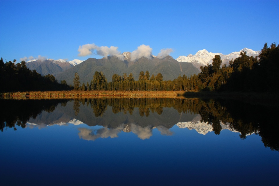
New Zealand: Lake Matheson & the southern Alps at sunset

Rewards go to the patient, especially those on daytime walks through the temperate rainforest to the Franz Josef Glacier and the Fox Glacier.

After all, this area is a UNESCO World Heritage Site.

After my visit to Fox Glacier earlier in the day, I arranged for a short 10-minute shuttle from Fox Glacier town to Lake Matheson (Te Ara Kairaumati) before sunset. Even in winter’s low-season, I was surprised by how few people were around to enjoy the view.

The sequence of photos below span a period of just over one hour in time. Appearing in most of the photos are the two grand snow-frosted peaks: Mount Tasman (Horokoau) on the left and Aoraki (Mount Cook) on the right.

( Click here for more )

New Zealand: forest walk to Fox Glacier

With coach services, I’ve been making my way down the west coast of New Zealand’s South Island. I spend a couple of days around Franz Josef town, and I describe the walk from town to the Franz Josef Glacier.

Will a visit to the Fox Glacier be as memorable? To find out, I head south on Highway 6 (Haast Highway) to Fox Glacier town, some 20 kilometres from Franz Josef town. Fox Glacier town was once known as Weheka which is also the original Māori name for Cook river nearby.

( Click here for images and more )

New Zealand: slow bound to Franz Josef Glacier

To a person, from the InterCity coach driver to the proprietors of motels along the South Island’s west coast, everyone spoke about how the Franz Josef and Fox Glaciers are two of the most accessible glaciers in the world. All things being equal, reaching the glaciers is definitely easier with a vehicle.

But I’m on New Zealand’s South Island, in the middle of a rainforest, and within the Westland National Park which is part of a UNESCO Heritage Site. I’m in no rush; so I think I’ll spare the trees from the expelled products of a combustible engine.

( Click here for images and more )

New Zealand, true-colour image from NASA Terra satellite, December 2002.

Travel Memories of New Zealand’s South Island

It’s good to stop for a moment, step back, and consider the journey: the places visited, the impressions accumulated, the conversations and ideas left behind. In the midst of career change and year-long RTW travel, every moment becomes a potential highlight. I’ve been keeping all of my senses tuned, and in the southern winter’s low-season, it has become more than just a possibility, with far fewer people on the roads and at various sites.

When Christina Hegele asked if I might participate in a blogger relay, I was in the last stages of my July 2012 visit to New Zealand’s South Island. Te Wai Pounamu o Aotearoa has provided some of the finest travel highlights, a conclusion shared by many.

( Click here for more )

%d bloggers like this: