Fotoeins Fotografie

location bifurcation, place vs. home

Posts from the ‘Architecture’ category

U Kasaren, Hradcany, Prag, Prague, Praha, Czech Republic, fotoeins.com

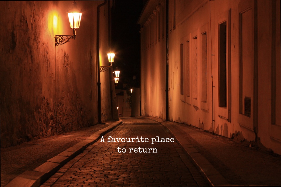
My Prague: a favourite place to return

Above/featured: U Kasáren from Loretánská, Hradčany – 30 July 2016 (HL).

On a personal level, the impact of this city can’t be gauged, measured, or quantified. What I know is I’ve roamed this place over countless little cobblestones. The sum of all strides led me to jumping continents and traversing nations with steps as large as my imagination could entertain and overcome.

And so, after the twelfth, fifteenth, or twentieth visit (I’ve lost count), I look at these images and ask why I surrender to the pull, why I return, and why the Czech capital city feels familiar. It’s about the old and the new, a colourful combination replacing what I’ve lost and amplifying what I’ve gained.

Prague is one of my favourite places to return.

summer sunrise, sunrise, summer, Karluv most, Charles Bridge, Prag, Prague, Praha, Czech Republic, fotoeins.com

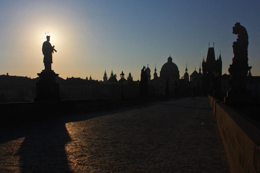
Daybreak and a halo for St. John of Nepomuk, Charles Bridge (Karlův most) – 28 July 2013 (HL).

National Monument, Vítkov, Zizkov, Prag, Prague, Praha, Czech Republic, fotoeins.com

Over the city to the west from the National Monument on Vítkov (Národní památník na Vítkově), Žižkov – 2 August 2013 (HL).

Muzeum, stanice metra, metro station, DPP, Prag, Prague, Praha, Czech Republic, fotoeins.com

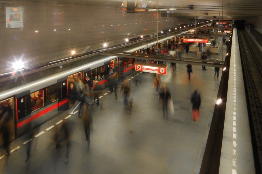
Metro line C commuters at Muzeum station – 8 November 2016 (HL)

Ginger and Fred, Fred and Ginger, Dancing House, Tančící dům, Prag, Prague, Praha, Czech Republic, fotoeins.com

Dancing House (Tančící dům) with streaking northbound streetcar, Nové Město – 6 November 2016 (HL)

I wrote a “love letter” to Prague, which as many have discovered also includes “the night watch.”

I made all of the above images in 2013 and 2016. This post appears on Fotoeins Fotografie at fotoeins.com as https://wp.me/p1BIdT-bCs.

Marienplatz, MVG München, U-Bahn, München, Munich, Germany, fotoeins.com

From the World Outside & Into Munich’s Metro

Above/featured: U-Bahnhof Marienplatz.

After dozens of visits since 2002 to Germany’s Munich, I’ve become familiar with the city’s transport network. For the city’s residents, the day-to-day work commute from the upside and into below can merge into a monotonous grind. The following images within five U-Bahn or metro sitations might challenge that notion with ghost-like and otherworldly appearances.


Georg-Brauchle-Ring

Georg-Brauchle-Ring, MVG München, U-Bahn, München, Munich, Germany, fotoeins.com

7am morning commute (IG)


Hauptbahnhof

Hauptbahnhof, MVG München, U-Bahn, München, Munich, Germany, fotoeins.com

Bahnland Bayern (IG)


Lehel

Lehel, MVG München, U-Bahn, München, Munich, Germany, fotoeins.com

One foot in front of the other … (IG)


Marienplatz

Marienplatz, MVG München, U-Bahn, München, Munich, Germany, fotoeins.com

U6, nach/to Klinikum Grosshadern (IG1, IG2)


Westfriedhof

Westfriedhof, MVG München, U-Bahn, München, Munich, Germany, fotoeins.com

Comings and goings (IG)


I made all pictures above between 22 and 24 February 2017 inclusive. Alle Fotoaufnahmen sind mit Wasserzeichen versehen worden. This post appears on Fotoeins Fotografie at fotoeins.com as https://wp.me/p1BIdT-buj.

Freistaat Bayern, The Free State of Bavaria

Bavaria: 100 years of statehood (2018)

Featured image: The blue and white diamonds (fusils) are a familiar Bavarian symbol, adopted in the late 13th-century by the Wittelsbach family who ruled Bavaria from 1180 to 1918.

As a product of the coastal and mountainous Canadian Southwest, I always feel the pull exerted by the Bavarian Alps regardless of where I am in Germany; it’s been this way over the past 18 years. But there’s more to Bavaria than fairytale castles, Oktoberfest, and BMW, although they’re spot on for the Wurst (sausage). And frankly, there’s a ton more to Germany than Bavaria, but that’s one of many reasons for this entire blogsite after all.

Located in southeast Germany, Bavaria includes more than a half-dozen World Heritage Sites, the pre-Easter Fasching/Fastnacht festival, the sight of Audis on the Autobahn, over one thousand years of wine-making in Franconia, and violin-making since the late 17th-century, among many things to explore, eat, and experience.

( Click here for more )

The Spheres, Amazon Spheres, 6th and Lenora, Amazon, Denny Regrade, Denny Triangle, Seattle, Washington, fotoeins.com

Seattle: curious glowing Amazon Spheres

Above: (A) The Spheres, northeast from 6th Avenue and Lenora Street (HL).

Glowing glass forms appear around the corner as if they’ve risen suddenly from the ground, eliciting odd looks and interested inquiries from passersby.

On Amazon’s urban campus at the feet of towers Day One and Doppler, The Spheres are located in downtown Seattle on Lenora Street between 6th Avenue and 7th Avenue. The futuristic structures provide a highly visible centre of attention for the electronic-commerce and -computing company. Three intersecting glass and steel half-spheres will contain a botanic garden to include exotic plants, waterfalls, and treehouses, and workspaces to further cultivate creativity by and collaboration among Amazon employees. The grand opening is scheduled for 18 January 2018.

The construction development projects are part of the joint efforts by NBBJ and Amazon to regenerate the Denny Regrade area with ample office space for the world headquarters of Amazon, and additional space for retail and public facilities.

The Spheres, Amazon Spheres, 7th and Lenora, Amazon, Denny Regrade, Denny Triangle, Seattle, Washington, fotoeins.com

(B) The Spheres, northwest from 7th and Lenora (HL).

Seattle Municipal Archives, item no. 4011

(C) Seattle Municipal Archives, item no. 4011.

Denny Hill was regraded and removed in multiple phases between 1898 and 1931. In the 1930 picture above (C), the 2017 Spheres in image (B) would be located to the right of the utility pole between the two cars in the foreground and the digging excavator in the background.


I made photos (A) and (B) above on 10 December 2017. This post appears on Fotoeins Fotografie at fotoeins.com as https://wp.me/p1BIdT-aVe.

Koblenz: 1st and 2nd Deutsches Eck (German Corner)

Above: West view to Deutsches Eck from Ehrenbreitstein. 2015 photo by Taxiarchos228 (Wladyslaw Sojka). I’ve added the following labels: (1) Seilbahn/Gondola, (2) St. Kastor Basilica, (3) Deutschherrenhaus, (4) first Deutsches Eck, (5) Memorial to German Unity (Kaiser Wilhelm Memorial), (6) reclamation in the late 19th-century, (7) second Deutsches Eck.

Many will know, have seen, or have read about the Deutsches Eck (German Corner) in the German city of Koblenz. The river city has plenty to provide: visitors wander into the vineyards to sip on crisp white wine from local grapes, vacation on long cabin-boats to enjoy the river scenery, or explore the surrounding Upper Rhine River Valley.

But Koblenz is also well known by virtue of its name after the junction where the rivers Moselle and Rhine meet. By the first-century AD/CE, the Romans had built for strategic protection a fort1 called “Castellum apud Confluentes“, Latin for “the castle at the confluence”. What most commonly acknowledge as the Deutsches Eck (German corner) is not the original location. Half concealed among the trees some 200 metres back near the Deutschherrenhaus is the first location of the Deutsches Eck.

What follows:

  • a map to the area and my photos from the present-day,
  • a short history of the “Deutsches Eck,” and
  • archival images from the mid-16th century to early 20th century.

( Click here for images and more )