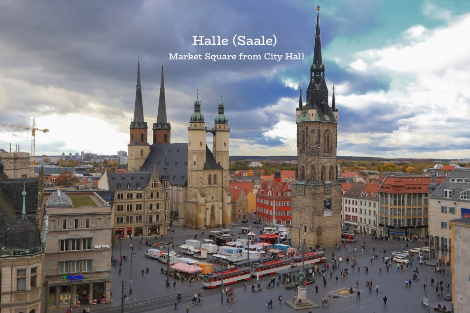
Fotoeins Fotografie

location bifurcation, place vs. home

Tulips alight, Skagit Valley Tulip Festival (2017)

I was skeptical of a visit to tulip gardens.

“They’re just flowers after all.”

When I lived in Heidelberg, Germany, my friends wanted to travel to the Netherlands before their first-born kicked into full swing. They wanted to visit Keukenhof and Amsterdam. I was excited about Amsterdam; I was unsure about Keukenhof. But one step inside the tulip gardens in Keukenhof was enough to turn my head, and my opinion about tulip fields spun completely around.

That was 2002, and this is 2017. Travelling from the Canadian southwest, I’m on highway I-5 into western Washington State to see some tulips.

During the annual tulip festival in April, the Skagit river valley is populated by fields of daffodils and tulips, in eye-popping yellows, reds, oranges, purples, and whites. The overcast skies with diffuse grey light provides ideal light conditions with no strong shadows. The explosion of colours seem to blend into an extensive painting of the fields.

( Click here for images and more )

Martin Luther, Museum Lutherstiege, St.-Anna-Kirche, Augsburg, Bayern, Bavaria, Germany, fotoeins.com

Augsburg: Luther vs. Cajetan (1518), Confessions (1530)

Above/featured: REVOCA! (Cajetan to Luther, 1518), Museum Lutherstiege.

With its founding date as “Augusta Vindelicorum” by the Roman Empire in 15 BC/BCE, Augsburg is one of the oldest cities in Germany, and has ties with Martin Luther and the Reformation which marks its 500th anniversary in 2017.

Months after making his 95 Theses known to church authorities and the public, Martin Luther was called to the free imperial city of Augsburg in 1518 by Cardinal and papal legate and representative Cajetan to answer charges of heresy, for challenging the morality of indulgences, and for questioning the supreme authority of the Pope. Cajetan urged Luther to recant or revoke his statements (“revoca!”), but Luther held firm and refused to obey Cajetan.


( Click here for images and more )

Laupahoehoe Point, Laupahoehoe, Hamakua Coast, Big Island, Hawaii, USA, myRTW, fotoeins.com

Hawaii Big Island: A Tranquil Tip at Laupāhoehoe

I’m standing in the warm ocean breeze, with rustling palm trees and crashing ocean surf for company. My friend appears from around the corner, and she tosses me a look before breaking out to a smile; I must be sporting a ridiculous gobsmacked expression.

New land laid with volcanic lava takes days, weeks, even years; but breaking the land down takes millions of years. Even with abundant foliage as partial deterrents, the absolute power of moving water and the unstoppable process of erosion must produce the inevitable; the hardest of rock gets pounded into submission, broken and ground down to fine particles of sand. But all that fun geology is forgotten in this rural idyll next to the open ocean, and it’s a big reason why about 600 people make this place their home.

On the Big Island of Hawaii, the drive on the number 19 Mamalahoa Highway north from the state capital city of Hilo turns northwest along the Hāmākua Coast. The scenery becomes a mix of grassy meadows along the descending flank of the Mauna Kea volcano, accompanied by deep gulches and steep cliffs dropping into the Pacific Ocean.

The word Laupāhoehoe means “a flat or tip of smooth lava” for the tip of land that sticks out into the water. At its peak in the late 19th- and early 20th-century, more than two thousand people lived in the town, self-contained with a school, stores, and a hospital. Taro root farms, cane plantations, and the Laupāhoehoe Sugar Factory (1880) provided employment and the local economy. Factory operations ceased in the mid-1990s, bringing a century of sugar-making along the island’s east coast to an end.

On 1 April 1946, a strong earthquake occurred inn the Aleutian islands on the Alaska coast. The resulting tsunami swept across the Pacific Ocean, and arrived at Hawaii at about 7am local time1. Waves up to 15 metres (50 feet) high hit the Big Island, creating widespread damage and killing over 150 people in total. At Laupāhoehoe, multiple waves struck, wiping out the only rail link to Hilo, and causing property damage; over 20 died, drowned, or went missing. After the tsunami, the school and houses moved back and further up the slope. The loss and subsequent abandonment of the rail line connection to Hilo meant a loss of transport, shipping, and tourism; the town population never recovered to the numbers in its heyday. The 1946 tsunami’s reach, power, and resulting destruction raised calls for an early warning system, and by 1949, the Pacific Tsunami Warning Centre was in operation in Hawaii.

Near the shoreline is a memorial to those who perished in 1946. Not far from the memorial, someone has jammed a fishing pole between rocks next to the breakwater. Life continues here, slowly and surely. The warm breeze still comes onshore, fallen palm fronds lay scattered on the beach, and ocean meets beach in a wet foamy crash.

Memorial to the perished at the 1946 tsunami (picture by Wmpearl for Wikipedia, CC1 license).
Laupahoehoe Point, Laupahoehoe, Hamakua Coast, Big Island, Hawaii, USA, myRTW, fotoeins.com

From Laupāhoehoe Point: east-southeast towards Welokā (centre) and Pāpa’Aloa. (centre-right)

Laupahoehoe Point, Laupahoehoe, Hamakua Coast, Big Island, Hawaii, USA, myRTW, fotoeins.com

Built in 1983 by the US Army Corps of Engineers, this breakwater consists of concrete tetrapod wave-breakers.

Laupahoehoe Point, Laupahoehoe, Hamakua Coast, Big Island, Hawaii, USA, myRTW, fotoeins.com

Life in the harbor.

Laupahoehoe Point, Laupahoehoe, Hamakua Coast, Big Island, Hawaii, USA, myRTW, fotoeins.com

1With Google Maps, the distance from Scotch Cap at the southwest tip of Unimak Island in the Alaskan Aleutian Islands to the northern tip of the Hawaiian island of Oahu is about 3700 kilometres (2300 miles). After the 1946 earthquake in Alaska, tsunami waves arrived at Hawaii about 5 hours after the earthquake, making the “surface speed” 740 kilometres per hour (460 miles per hour) which is consistent with general speed estimates. The Pacific Tsunami Warning Center created a model animation for the 1946 earthquake, and the video animation is on YouTube.

With one exception, I made the other photos on 21 January 2012 at the beginning of my year-long RTW. Thanks to MK for guiding me to new and unseen (for me) parts of the Big Island. This post appears on Fotoeins Fotografie at fotoeins.com as http://wp.me/p1BIdT-9jx.

street art, mural, Herakut, Metropolink, Heidelberg, Germany, fotoeins.com

My Heidelberg: Herakut street art for Metropolink

It’s amazing what gets discovered after going the wrong way.

I head straight for a full city-block before realizing my error, that I should’ve turned right about 5 minutes ago. I bow my head, and release a deep breath in frustration. I raise my head to the sky, when I catch sight of something out of the corner of my eye.

What’s that across the street?

I have to reach my destination which I know isn’t far.

But I am coming back here to get the shot.


( Click here for images and more )

Oberstdorf, Oberbayern, Upper Bavaria, Bavaria, Allgaeu Alps, Alps, Germany, fotoeins.com

Oberstdorf: Sunday Allgäu night auf Deutsch

Why multiple languages rock my world

With fewer than ten-thousand inhabitants, Oberstdorf in southern Bavaria is as its German name suggests: an “upper village” tucked in the Allgäu Alps near the German-Austrian border. Yet, the town feels busy and full with skiers, snowboarders, and winter hikers.

It’s Sunday night and I’m on the hunt for “schnitzel and spätzle.” With my eye already on a place, I arrive at 630pm to a full house. I don’t have a reservation (which is dumb in a small town), but a table of four is available (which is fortunate). The server offers me the table, with the condition I’ll be sharing the table if two people want places. “Alles klar,” I reply.

I order a standard half-litre Weizen beer, along with the required schnitzel-and-spätzle platter. An elderly couple is offered two places at my table; they take one glance in my direction, and they’re gone. The server wears a puzzled look, and I can only shrug. A second couple arrives ten minutes later, and as they approach my table with curiosity, I tell them “die Plätze sind noch frei” (the places are available). They express their thanks, and take their seats across from me. Those last five German words set a positive tone for the rest of the evening.

( Click here for more )