It’d been a long time since I’d been “home” in Vancouver during northern summer, and I thought it would be a great idea to rediscover my hometown from sunrise to sunset on the 1st of July, or Canada Day when the country celebrates its nationhood.
With 16 hours of daylight, I set out to select one photo made for every hour of daylight. I gathered 18 photographs, including images at sunrise and sunset.
A short intro
As one of the four cardinal directions, North is for most a simple orientation concept. But North has always held special and personal meaning.
For many years, I’d walk to school every day, and I always had the company of the mountains to the north. Sometimes, they’d wear white puffy hats and I couldn’t see their rounded green tops. Every day, I’d look north, and nod a voiceless “hello” towards my giant friends.
They’re known as the North Shore mountains, but at 4000-feet (1300-metres), they’re more likely to be mentioned as “north shore hills” in conversations among residents. A general rule of thumb for first-time visitors to Vancouver is that if you’re facing the mountains, you’re heading north.
At 49-degrees north latitude, sunrise in summer occurs to the northeast; the azimuth for sunrise on 1 July is 52 degrees (north is zero; east is 90).
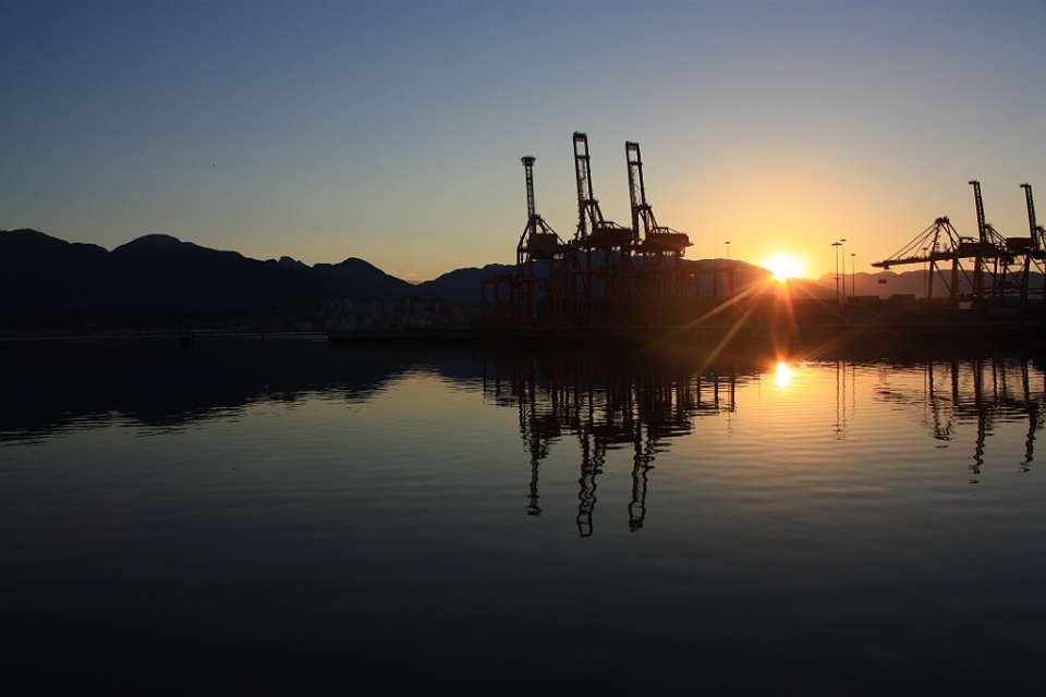
1. 511am, sunrise – Port of Vancouver
The first rays appeared at 540am, because standard sunrise-sunset times assume locally flat horizons. The stationary container-cranes stood tall in salute, with one crane on its side pointing “conveniently” to the emerging sun. This view also faces the indigenous landmark called Ḵ’emḵ’emel̓áy̓, meaning “maple trees” in the Sḵwx̱wú7mesh language of the Squamish people; the landmark would become the Hastings Sawmill at the foot of Gore Street, and is now the Port of Vancouver’s CenTerm terminal.
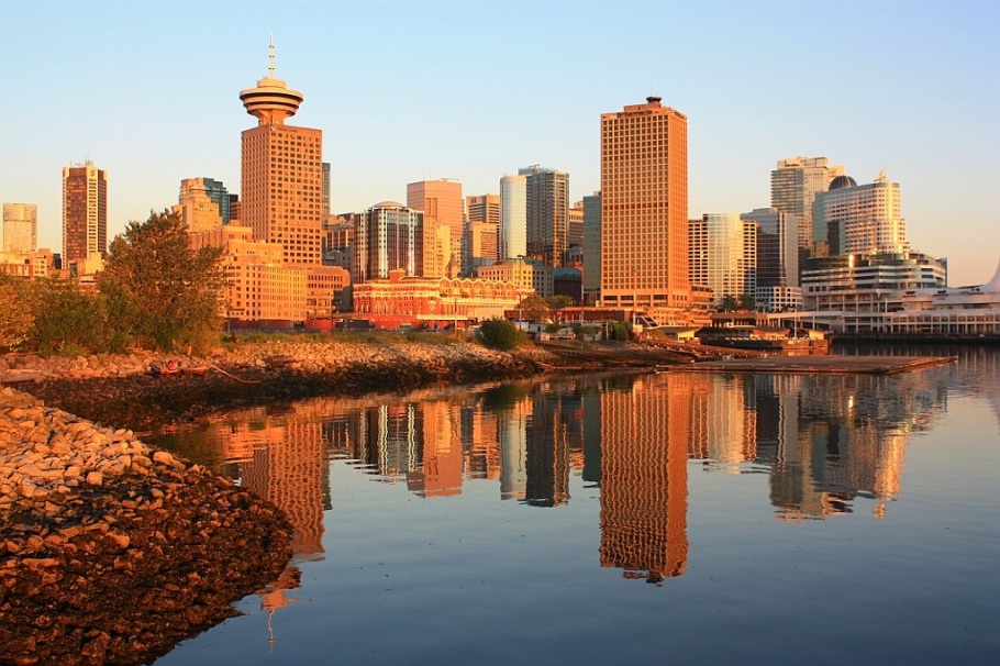
2. 511-600am – CRAB Park at Portside
With the rising sun to the northeast, the Vancouver city skyline is bathed in warm light at dawn. CRAB Park at Portside provides a perfect vantage point to observe the morning illumination. About one hundred years ago, this same area marked a water passage between Burrard Inlet and False Creek; this location has the name Leḵ’leḵ’i in the Sḵwx̱wú7mesh language of the Squamish people.
3. 601-700am – Gastown
I hadn’t planned the shot, but there might be something to say about the similarity of and/or the relationship between the box-like appearance of the towers in the background and the rectangular-box like shape of shipping containers in the foreground.
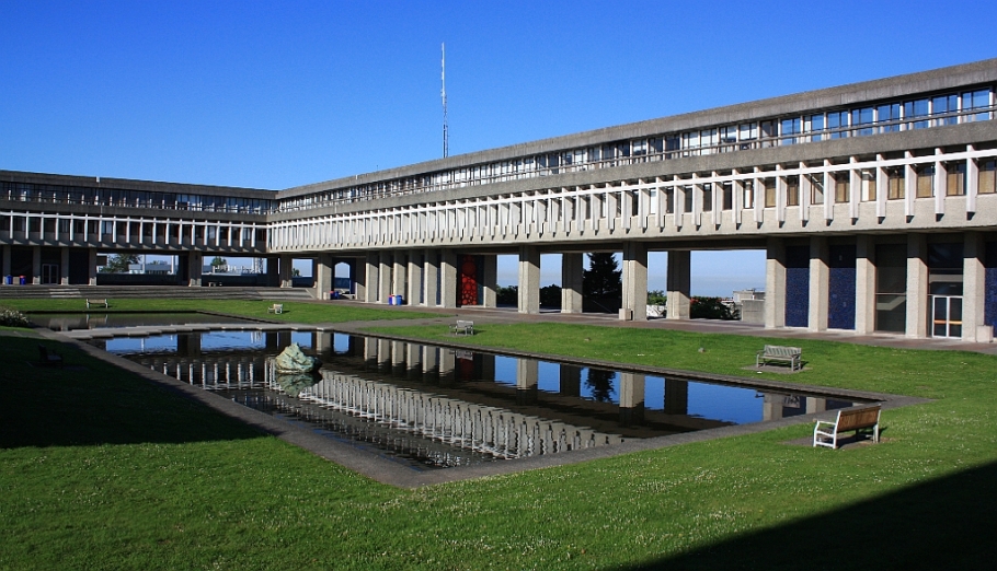
4. 701-800am – SFU AQ Pond
I spent five years at Simon Fraser University (SFU) and during the regular fall-winter sessions, the cloud deck is often below Burnaby Mountain, which means the university campus is buried in an opaque grey. The long stretches of fog can be distressing and depressing. But on this clear summer morning, I’m reminded why this view of the Academic Quadrangle and the adjacent pond is symbolic for SFU.
5. 801-900am – SFU Convocation Mall
SFU’s W.A.C. Bennett Library (left); Mount Seymour (right). One of the attractions to attending SFU was the view; I’ve always been a sucker for a pretty face. Fortunately, I also learned about engineering, mathematics, and physics, enough to earn a B.Sc. degree in physics.
6. 901-1000am – Deep Cove
That’s a calm and idyllic morning on the water. Decades ago, Dad took the family out for a daytrip to Deep Cove. I don’t recall most details, but I remember being speechless at the sight of the “impossibly” tall mountains in Indian Arm.
7. 1001-1100am – Lonsdale Quay
Lonsdale Quay in North Vancouver provides a great view of Burrard Inlet and the Vancouver city skyline; the seaplane at the upper-right is on approach to land in Vancouver harbour. For nibbles and drink, the variety of different food on offer inside Lonsdale Quay Market is good and tasty, too …
8. 1101am-1200pm – Seabus (Burrard Inlet)
Operating since 1977, the Seabus ferries commuters and visitors across Burrard Inlet. I’m sure many jaded commuters won’t think to photograph out the windows, but on a sunny day, there aren’t better photographic opportunities, even if there isn’t access outside. On the journey from North Vancouver south across the water to Vancouver, I’m pointing my camera west towards First Narrows and the Lions Gate Bridge, with the other SeaBus passing by and the ever present mounds of bright yellow sulphur.
9. 1201-100pm – Burrard Inlet
With the North Shore mountains as backdrop, the sight and sound of seaplanes arriving and departing the water-runway of Burrard Inlet are evidence to another (extra)ordinary day in Vancouver.
10. 101-200pm – Granville Street
VIVA Vancouver festival: various streets including Granville Street are closed to vehicular traffic for music, arts and crafts, food, etc.
11. 201-300pm – Steveston Festival
In Richmond’s Steveston area, I hear salsa and merengue music, and happy shouting en español. The small group of dancers produces an infectious atmosphere and gathers curious onlookers – who am I to deny the unspoken gravity? Fortunately, the obliging dancers continue dancing and smiling for the camera.
12. 301-400pm – Steveston Wharf
This boat moves slowly out from the muddy Fraser River and into the waters of Georgia Strait. Many years ago, Dad took us fishing with one of his friends here in Steveston. Seeing the calm of the river, the promise of open sea, the big skies, and the mountains looming afar on Vancouver Island, I sense the magic again, once-buried memories from the past stretching out as tendrils into the present.
13. 401-500pm – Marine Drive station
SkyTrain Canada Line northbound on the North Arm Bridge over the Fraser River. Facing south in the last-car of the train, overhead is Lufthansa flight LH476 (Airbus 330-300) non-stop from Munich, Germany, on approach to YVR airport. Anyone who lands at Vancouver airport can take public transport with the SkyTrain directly into downtown Vancouver.
14. 501-600pm – UBC Main Mall
University of British Columbia (UBC) campus: Main Mall to Flag Pole Plaza, and beyond to Georgia Strait. Sitting on the cliffs at Point Grey, the university seems to reach out physically into the waters and to the mountains. It’s difficult to know for sure whether that’s merely an academic exercise, but no matter, I learned some more physics and astronomy here at UBC.
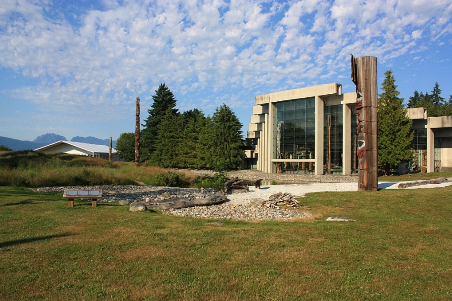
15. 601-700pm – UBC Museum of Anthropology
The Museum of Anthropology (MOA) is one of my favourite places to visit in the city. My first exposure to First Nations’ came from the exhibits at the MOA where I learned about the people, culture, and traditions. My parents are immigrants to Canada, and we are the first in our generation as Canadians. The words “resident”, “immigrant”, and “visitor” become suggestive, if not provocative. Coming back here reminds me to continue looking and listening.
16. 701-800pm – Robson Square
Robson Square (Robson, between Howe & Hornby): there are wooden benches on wooden pallets, set into the middle of the street. If it’s not officially pedestrianized, Robson Square might as well be. The former provincial courthouse is presently home to the Vancouver Art Gallery.
17. 801-900pm – Hon’s Wun-Tun House
BBQ-pork wonton noodle soup with Chinese broccoli: Hon’s (Wun-Tun House) on Robson. There are perhaps better places elsewhere, but I’ve known Hon’s since childhood, and every time I have their wonton noodle soup, I’m home.
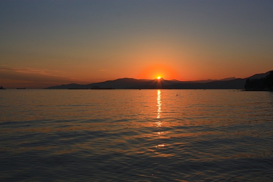
18. 921pm, sunset – English Bay Beach
Sunset over English Bay. What the photo doesn’t show is how packed the beach was with families, children, couples, and small groups, all enjoying the remaining time in the holiday weekend. Do they understand that the position of the setting sun will drift progressively south as summer gives way to autumn and winter? Do they care? Probably not …
A short outro
Standing in the sand at First Beach, I look north and west, beyond English Bay (Salish Sea) to the mountains on the Sunshine Coast. The azimuth for sunset on 1 July is 308 degrees to the mountains between Gibsons and Sechelt, over which the summer sun now sets.
True north is a constant presence in summer, and speaks to the nature about how residents of the city view themselves and their surroundings. For a few weeks, the northern sky in summer never gets truly dark during the period of time in the day called “astronomical twilight”. In other words, the sun never goes under 18 degrees below the horizon, and for a couple of weeks around the solstice, the night-time sky between 10pm and 4am looks like a “permanent state” of dusk to dawn.
In true north lies the promise of a summer that never ends.
I’ve marked the location of every photo in the map below.
I traveled to and visited all of the locations with a $9.75 DayPass on TransLink public transport. Over a period of over 16 hours, I made a total of 14 trips with the bus, community shuttle, SeaBus, and SkyTrain. With a single fare of $2.75 per trip (valid for 1.5 hours), careful timing and planning could have amounted to a minimum of 11 trips (16 hrs/1.5 hours rounded up), which with cash fares sum to a total of $30.25, for a minimum savings of $20.50. I covered a total of 120 kilometres (75 miles), not including additional walking distance; see the map below.
I made all of the photos above on 1 July 2013; all (except photo number 17 with a 4th-generation iPod Touch) were made with the Canon 450D (XSi) camera. This post appears on Fotoeins Fotopress at fotoeins.com.
Hi and thanks, Anita! You can imagine that I had a very long day, being awake at 4am, and finally lights out at about 1am. It helped I was already familiar with the entire area, and I had a good idea where I was going and what routes on public transport to take; I also have the internet to thank for that. I’m figuring out how much distance I covered (it’s a lot!), and I’ll add the number as a note later. I hope you had a great Canada Day in the Ottawa-Outaouais region! 🙂
Great post! Like you, this was my first Canada Day back in Vancouver and I definitely agree – the mountain’s mean north. That was what my parents and teachers always said as I was growing up.
It was great to follow along on your day’s adventures. I was trying to map it all out in my head. Pretty incredible how far you can get with just a day pass on Translink. How did you go from SFU Burnaby to Deep Cove? Is there some hidden route there that I don’t know about?
Hi and thanks, Adelina! It was a little strange to celebrate the national holiday in my own country, and to be back in my own hometown provided an extra special thrill; I’m sure you felt the same way too on Monday. Wasn’t that a beautiful (hot) sunny Canada Day? I thought it was perfect.
I’ve been trying to include an extra Google Map at the bottom of the post, showing most of the routes I took on my day “out and about” throughout Vancouver. If I can get that figured out, I’ll append another map to the post.
It might not be obvious, but here’s how I went from SFU Burnaby Mountain to Deep Cove:
* from SFU Burnaby, I’m on the 135 westbound bus to Vancouver, disembarking on East Hastings Street at Kootenay Loop (just west of Boundary Road).
* at Kootenay Loop (curbside on East Hastings), I can take either the 28 or 130 across the 2nd Narrows Bridge to Phibbs Exchange in North Vancouver.
* from Phibbs Exchange to Deep Cove, I can take the 211 or 212 bus, or the C15 community shuttle, although I think the “regular” bus is faster.
* From Deep Cove, I can ride the 211, 212, or C15 back to Phibbs Exchange. From here, you can go to North Vancouver (Lonsdale Quay, Grouse Mountain, Lynn Canyon), West Vancouver, Burnaby, or to downtown Vancouver.
Hope that helps! Thanks again for reading and for your comment, Adelina!
Hi, Cathy – I’m glad I could provide a visual tour of Vancouver on Canada Day. Do come (back) all the way up the I-5 and visit! 🙂 Thanks for reading and for your comment!
Hi, Alouise, and thanks! I hope the photos provided some good memories of your previous visit to Vancouver, and perhaps, provided a little extra encouragement for a return visit in the near future! 🙂 Thanks again for reading and for your comment!
[…] To borrow a friend’s phrase, this scene appears to show metal dinosaurs out for an early-morning drink. With the knowledge of a 16-plus hour day ahead, the effort of being awake at 415am and present at the waterfront at 5am on Canada Day was worth the quiet surroundings at dawn and the anticipation of a beautiful summer sunrise. To read more about what transpired over the next 16 hours, please read my post at fotoeins.com. […]
[…] For the 3rd consecutive year, I’ve embarked on another marathon to photograph some of the places and activities during Canada Day in the greater Vancouver area. In this 2015 edition, I’ve collected 20 photographs throughout the holiday, including photographs at sunrise and sunset. This year’s marathon follows my effort last year (2014) and the debut effort in 2013. […]
[…] New Year’s Day 2015: Vancouver, Canada • Canada Day 2014: Vancouver, Canada • Canada Day 2013: Vancouver, Canada • New Year’s Day 2012: Point Reyes, CA, […]
[…] edition – Canada Day 2015 • 2nd edition – Canada Day 2014 • 1st edition – Canada Day 2013 • The National Anthem with the Heritage Horns, 12pm daily in Vancouver • […]
[…] The forecast called for a hot mostly sunny day to celebrate Canada’s national holiday on the 1st of July. It’s another invitation to continue exploring my birthplace here in Vancouver, British Columbia. Spanning a period of 16-plus hours including sunrise and sunset, I’ve collected 20 photographs among 100 kilometres (60 miles) of travel throughout the region. This year’s marathon follows last year’s debut effort. […]
[…] 2016 • 3rd edition – Canada Day 2015 • 2nd edition – Canada Day 2014 • 1st edition – Canada Day 2013 • The National Anthem with the Heritage Horns, 12pm daily in Vancouver • The National […]


19 Responses to “16 hours on Canada Day in Vancouver (2013)”
Very cool…so many great shots. It is amazing how much ground you could cover on public transport…the google map really puts it in perspective.
LikeLike
Hi and thanks, Anita! You can imagine that I had a very long day, being awake at 4am, and finally lights out at about 1am. It helped I was already familiar with the entire area, and I had a good idea where I was going and what routes on public transport to take; I also have the internet to thank for that. I’m figuring out how much distance I covered (it’s a lot!), and I’ll add the number as a note later. I hope you had a great Canada Day in the Ottawa-Outaouais region! 🙂
LikeLike
Love it!
LikeLike
Thanks, Tom! You’d be forgiven if you were left with the impression that it “never” rains in Vancouver – but then again, how is it so green? 🙂
LikeLike
Great post! Like you, this was my first Canada Day back in Vancouver and I definitely agree – the mountain’s mean north. That was what my parents and teachers always said as I was growing up.
It was great to follow along on your day’s adventures. I was trying to map it all out in my head. Pretty incredible how far you can get with just a day pass on Translink. How did you go from SFU Burnaby to Deep Cove? Is there some hidden route there that I don’t know about?
LikeLike
Hi and thanks, Adelina! It was a little strange to celebrate the national holiday in my own country, and to be back in my own hometown provided an extra special thrill; I’m sure you felt the same way too on Monday. Wasn’t that a beautiful (hot) sunny Canada Day? I thought it was perfect.
I’ve been trying to include an extra Google Map at the bottom of the post, showing most of the routes I took on my day “out and about” throughout Vancouver. If I can get that figured out, I’ll append another map to the post.
It might not be obvious, but here’s how I went from SFU Burnaby Mountain to Deep Cove:
* from SFU Burnaby, I’m on the 135 westbound bus to Vancouver, disembarking on East Hastings Street at Kootenay Loop (just west of Boundary Road).
* at Kootenay Loop (curbside on East Hastings), I can take either the 28 or 130 across the 2nd Narrows Bridge to Phibbs Exchange in North Vancouver.
* from Phibbs Exchange to Deep Cove, I can take the 211 or 212 bus, or the C15 community shuttle, although I think the “regular” bus is faster.
* From Deep Cove, I can ride the 211, 212, or C15 back to Phibbs Exchange. From here, you can go to North Vancouver (Lonsdale Quay, Grouse Mountain, Lynn Canyon), West Vancouver, Burnaby, or to downtown Vancouver.
Hope that helps! Thanks again for reading and for your comment, Adelina!
LikeLike
Great idea and excellent photos of diverse subjects. Nice following along with you on your day in Vancouver. Very cool city.
LikeLike
Hi, Cathy – I’m glad I could provide a visual tour of Vancouver on Canada Day. Do come (back) all the way up the I-5 and visit! 🙂 Thanks for reading and for your comment!
LikeLike
Love this. It’s been a couple years since I was in Vancouver, but it’s such a great city. Love the photos.
LikeLike
Hi, Alouise, and thanks! I hope the photos provided some good memories of your previous visit to Vancouver, and perhaps, provided a little extra encouragement for a return visit in the near future! 🙂 Thanks again for reading and for your comment!
LikeLike
[…] wrote previously about having spent 16 hours on Canada Day and 120 kilometres on public transport to rediscover […]
LikeLike
[…] To borrow a friend’s phrase, this scene appears to show metal dinosaurs out for an early-morning drink. With the knowledge of a 16-plus hour day ahead, the effort of being awake at 415am and present at the waterfront at 5am on Canada Day was worth the quiet surroundings at dawn and the anticipation of a beautiful summer sunrise. To read more about what transpired over the next 16 hours, please read my post at fotoeins.com. […]
LikeLike
[…] • 16 hours, 18 photographs, & 120 kilometres on Canada Day […]
LikeLike
[…] • Canada Day 2014: Vancouver, Canada • Canada Day 2013: Vancouver, Canada […]
LikeLike
[…] For the 3rd consecutive year, I’ve embarked on another marathon to photograph some of the places and activities during Canada Day in the greater Vancouver area. In this 2015 edition, I’ve collected 20 photographs throughout the holiday, including photographs at sunrise and sunset. This year’s marathon follows my effort last year (2014) and the debut effort in 2013. […]
LikeLike
[…] New Year’s Day 2015: Vancouver, Canada • Canada Day 2014: Vancouver, Canada • Canada Day 2013: Vancouver, Canada • New Year’s Day 2012: Point Reyes, CA, […]
LikeLike
[…] edition – Canada Day 2015 • 2nd edition – Canada Day 2014 • 1st edition – Canada Day 2013 • The National Anthem with the Heritage Horns, 12pm daily in Vancouver • […]
LikeLike
[…] The forecast called for a hot mostly sunny day to celebrate Canada’s national holiday on the 1st of July. It’s another invitation to continue exploring my birthplace here in Vancouver, British Columbia. Spanning a period of 16-plus hours including sunrise and sunset, I’ve collected 20 photographs among 100 kilometres (60 miles) of travel throughout the region. This year’s marathon follows last year’s debut effort. […]
LikeLike
[…] 2016 • 3rd edition – Canada Day 2015 • 2nd edition – Canada Day 2014 • 1st edition – Canada Day 2013 • The National Anthem with the Heritage Horns, 12pm daily in Vancouver • The National […]
LikeLike