
San Francisco: Point Reyes National Seashore
My friend, Bill, suggested a trip north to the Point Reyes National Seashore, about 30 miles (50 kilometres) northwest from San Francisco. A worry was the weather which in the middle of winter can get foggy and windy. The National Park Service description states:
(The Point Reyes Lighthouse …) still stands in its original location, having weathered over 135 years at what is considered to be the windiest, foggiest location on the US west coast.
Not entirely encouraging.
But on this New Year’s Day, the sun was out, with temperatures in the low- to mid-60s F (+15 to +18C), a good breeze, and no fog in sight, providing ideal conditions to hang out along the Pacific Coast.
Point Reyes National Seashore
The Point Reyes National Seashore is a geologically diverse area, rich with history, flora, and fauna. The seashore lies adjacent to the San Andreas Fault Zone. The Fault (and Tomales Bay) bisects the territory with the lands of the Seashore lying on the Pacific tectonic plate to the west, and the Bolinas Ridge on the North American tectonic plate to the east.
In 1579, English explorer Sir Francis Drake is believed to have made repairs to his ship, the Golden Hind, with help from the Miwok inhabitants. Resembling the white chalky cliffs of Dover, England, Drake named the land “Nova Albion” or New England. Spanish explorer Sebastian Vizcaino sailed up the California coast in 1603, and anchored in what is now Drakes Bay during stormy weather. As his ships sailed back out to sea, Vizcaino named the area “La Punta de los Tres Reyes” to commemorate the day of the Feast of the Three Kings.
The way out


Point Reyes Beach South


Drakes Beach Road
Continuing the convergence of near-perfect conditions with luck, we caught sight of Tule Elk (south herd) and elephant seals (and some new pups).
The tule elk population was hunted to near-extinction towards the end of the 19th-century. A new program began in 1978 to repopulate the numbers. The population of free-range tule elk has recovered some, and the tule elk now number a few hundred. One of the two free-range herds is located in the southlands near Drakes Beach, where the following photos were made.
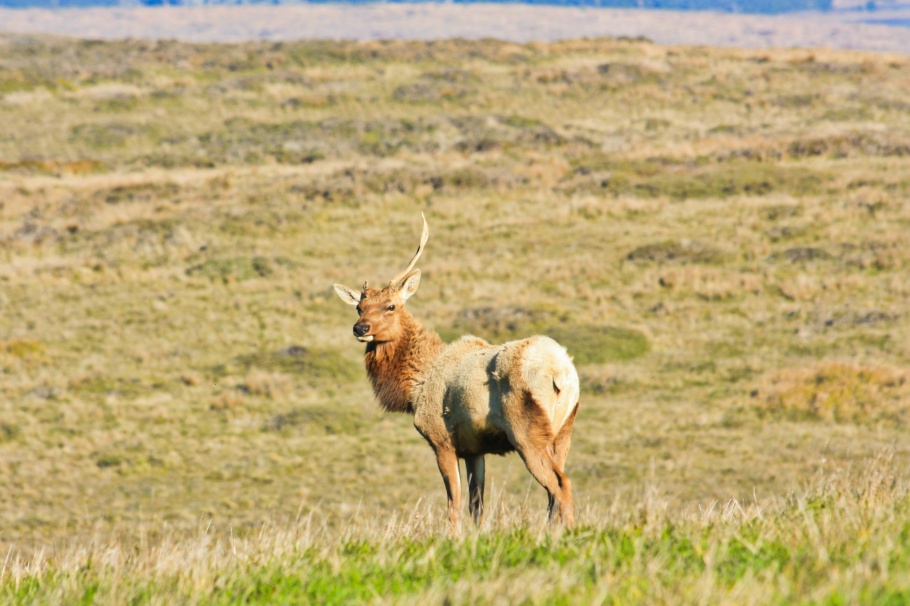
Tule elk, south herd: bull with missing antler.

Tule elk, south herd: “alpha” bull with its harem.
Point Reyes Lighthouse
The Point Reyes Lighthouse is located at one of the windiest and foggiest locations in North America. Completed in 1870, the lighthouse was manned until 1975 when the U.S. Coast Guard installed an automated light. Under bright sun, the Visitor Center on the upper cliff and the Lighthouse 300 feet below are in a beautiful spot. But it’s all too easy to imagine how foreboding and difficult the lighthouse would have been to maintain under thick fog, heavy winds, and driving rain.


Elephant seal overlook, near Chimney Rock
Elephant seals traveled up and down the west coast of North America. But like the whales, these seals were hunted to near-extinction for their oil-rich blubber. By the early 20th-century, hunting had been banned by the governments of Mexico and United States. In the 1970s, elephant seals reappeared at Point Reyes, after having been away for over 150 years. Now, these massive mammals now number about two thousand.


Directions to arrive at the Point Reyes National Seashore are described here. Public transportation is available but limited. The best way to visit is with a car to provide flexibility and capability to see the extent of the headlands. However, at certain times of the year, the only access to the Lighthouse and to the Elephant Seal Lookout at Chimney Rock is with the free shuttle-bus service to limit outside-traffic and its effects on the elk and seal populations.
I made all of the photos above on 1 January 2012 with a Canon EOS450D. This post appears on Fotoeins Fotografie at fotoeins.com as http://wp.me/p1BIdT-1fz.

15 Responses to “San Francisco: Point Reyes National Seashore”
Great Post Henry!!!! I wanted to say which photo I liked best, but it became to much 😉 so….. I love all of them!!!! What a fantastic day you ended up having!!!! 🙂 **
LikeLiked by 1 person
Hi, Xandré – I’m glad you enjoyed the post and the photos! It was a phenomenal New Year’s Day, because the weather was so good for an early-winter day, and because we got to see (from afar) Tule elk and elephant seals (and some pups). Thanks again for reading and your kind comments! 🙂
LikeLike
Interesting history and beautiful photos. I also had no idea they had elk there.
LikeLiked by 1 person
Laurel, thanks for stopping by and for your comments. I had read online about the elk and the seals, but we really lucked out with the sightings.
LikeLike
This is such a beautiful area! We went camping up there a few years ago and had such a fun time exploring all the different aspects of the seashore. There’s a ton of wild life, too (which you’ve captured super well). Beautiful photos, Henry; I especially like the one of the coastline (above the photo of the board w/ weather information). 🙂
LikeLiked by 1 person
Thanks for your kind comments, Christy! I’d always heard and read good things about Point Reyes, and it was very timely for my friend to suggest the day trip. Perhaps, next time I’ll head up to the very north end of the National Seashore towards the Tomales Point where the second Tule elk herd resides. 🙂
LikeLike
[…] Read more –> Point Reyes National Seashore […]
LikeLike
Great post, I’ve wanted to go up to Pt Reyes for years, we go to Marin often to different food destinations but haven’t spent any time hiking. Coincidentally, just this morning I read that the Point Reyes Lighthouse hostel just built a brand new green, eco-friendly lodge onsite and I was thinking about planning a trip up there! This gives me another reason to.
LikeLiked by 1 person
Hi and thanks, Cassie! I love how relatively isolated vast parts of Marin County appear, especially when one drives the 45- to 60-minutes north from the City. We were especially lucky to get a beautiful not-foggy warm sunny day at Point Reyes. Thinking about it again makes me want to go back and search for the Tule Elk again. 🙂 By the way, I love your post on the food in the City’s Ferry Building; you write about two of my favourites: the Ferry Building and food! Thanks again for reading and commenting!
LikeLike
Lovely photos. You saw a good deal of wildlife there that day. I have been to Pt Reyes twice but have not seen such large groups of seals, although I know they are there. There’s a lot to do there, and it’s hard to fit it all in.
LikeLiked by 1 person
Hi and thank you, Jenna! Remembering what I photographed and wrote and seeing your post also confirms what you’ve just said: it’s a big green space, and wouldn’t we all love to follow the north and south herds of Tule Elk, as well as seeing the seals come in and park themselves. I’d really like to go back and visit the the Bay Area now. 🙂 Thanks for stopping by and for your kind comment!
LikeLike
[…] • Canada Day 2015: Vancouver, Canada • New Year’s Day 2015: Vancouver, Canada • Canada Day 2014: Vancouver, Canada • Canada Day 2013: Vancouver, Canada • New Year’s Day 2012: Point Reyes, CA, USA […]
LikeLike
[…] Read: Point Reyes National Seashore […]
LikeLike
[…] Tule elk (Cervus canadensis nannodes): south herd’s alpha bull with a harem of cows – 1 … […]
LikeLike
[…] made the photos above on 1 Jan 2012 with a Canon EOS450D (Rebel XSi). Both images were made at 300mm focal length (480mm full-frame […]
LikeLike